Kingdom ZARAHEMLA since land of MANTI. Separated by SIDON
Posted: Sat Sep 10, 2011 1:05 am
Kingdom ZARAHEMLA since land of MANTI. Separated by SIDON
We already investigated the land of MANTI and nearby/around it. We could see how closely linked MANTI was to ZARAHEMLA, quite like being a natural extension because of the close geographic proximity and easy of military attacks from Zarahemla. We are to examine some features of MANTI while linking to Zarahemla and to the Jaredites.
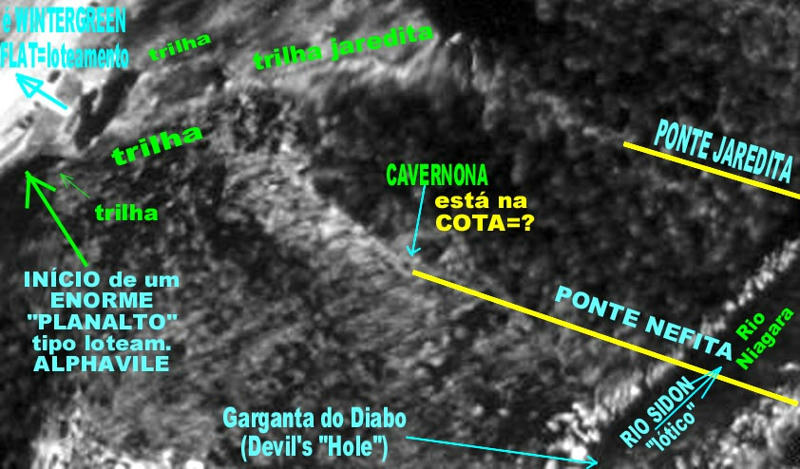
MANTI was a place ultra-important in the military strategy and economic trade place for Nephitic empire, because of its ultra-strategic position. Quite like that of Constantinople in the link between Europe and Asia. It is very evident that all trade from Zarahemla and from Nephites harbor to "head of Sidon River" (which is nowadays Chicago town, also the harbor for trade toward the Gulf of Mexico through Illinois River = West Sidon River branch) had to be controlled through the military town of MANTI.
Get into the Google Map:
http://maps.google.com/
In the box "maps", type in: Lake Tacoma, Detroit, MI, United States
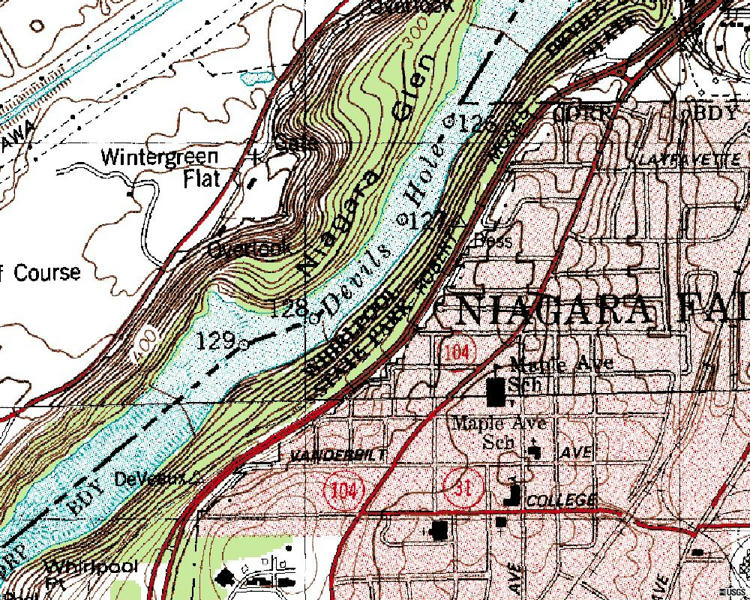
Press enter and you will see the Sidon River (Detroit River) flowing from EAST to WEST (your horizontal direction), as stated in the Book of Mormon, for NEARBY MANTI town. What is valid is the MAIN FLOW, the one used to stablish (set) the boundaries between the USA and CANADA. That is the "LEGAL" flow. The others are not considered. In any way the general flow direction of SIDON RIVER while passing through the region of MANTI TOWN is from EAST(ern) direction to the WEST(ern) direction, toward the SEA (WEST SEA) = Lake Erie.
In the left side, there is a "vertical bar" for the control of elevation. At the down part of the bar, there is a square with the minus signal (-) into it. Press it 1 times. See the result the pathway of Sidon River through the MANTI town and region (metropolitan area of Detroit). Repeat again for more 4 times. You can see that the GENERAL FLOW PATHWAY through MANTI TOWN and NEARBY IT is reasonably in the horizontal direction, thus from EAST to WEST DIRECTION.
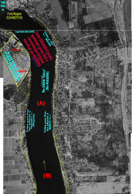
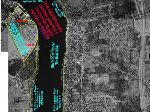
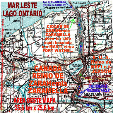
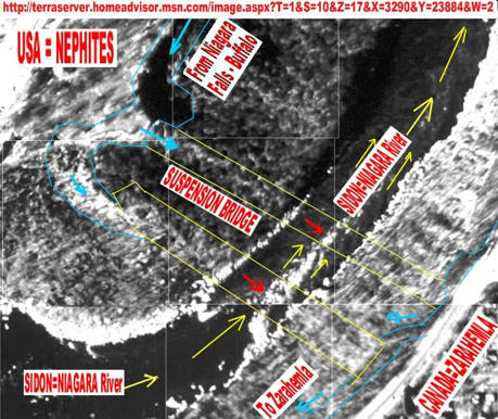
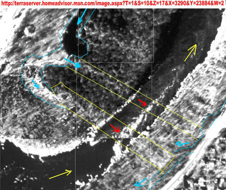
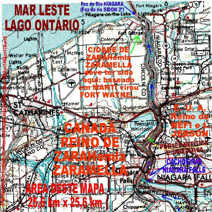
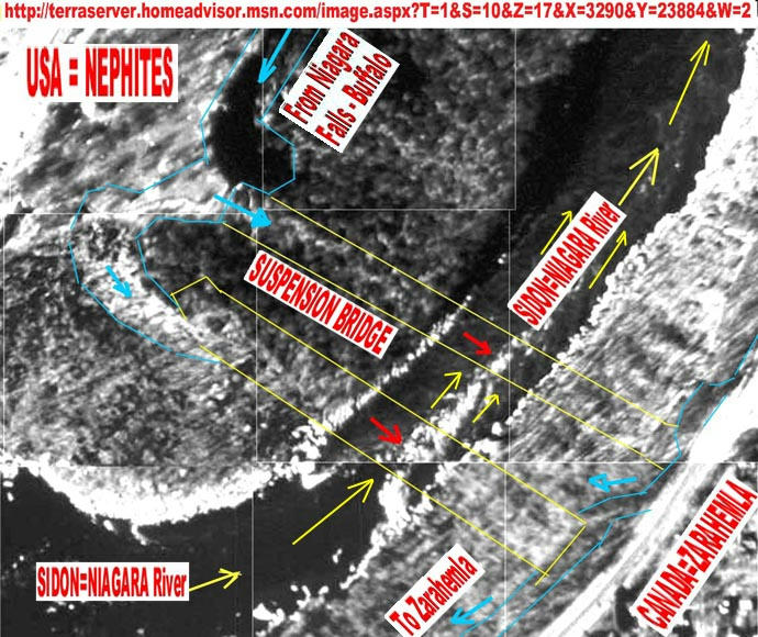
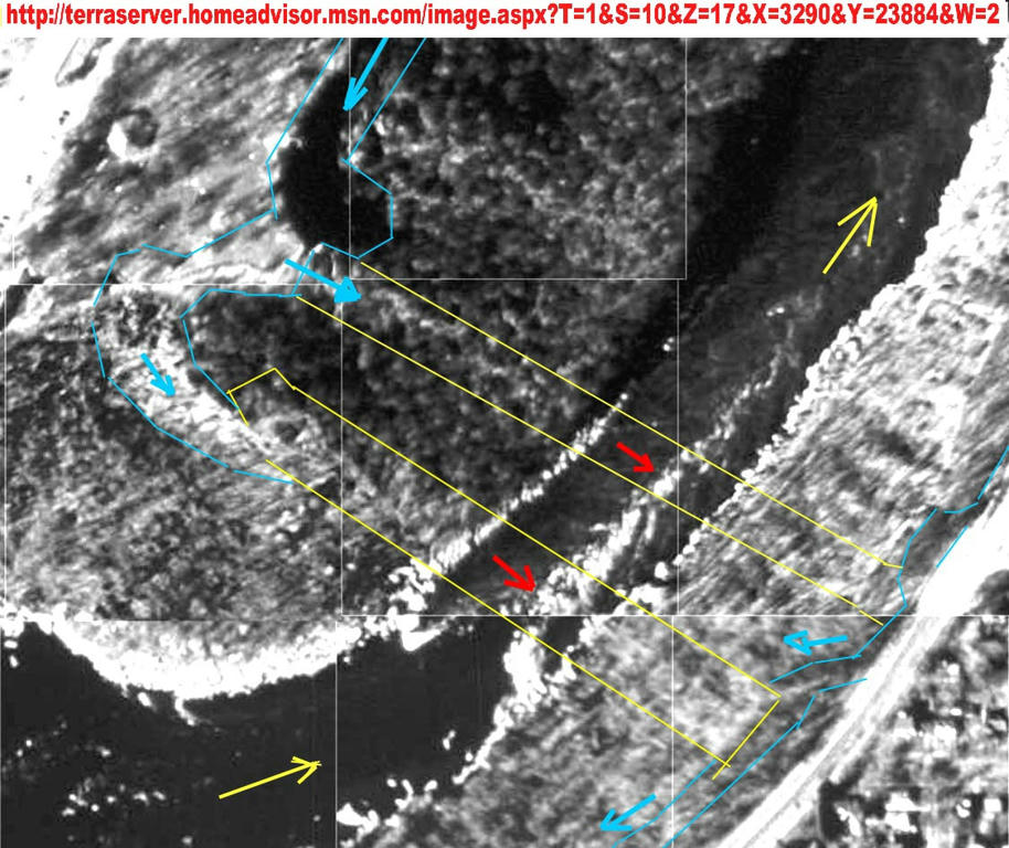
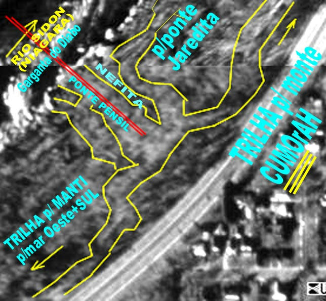
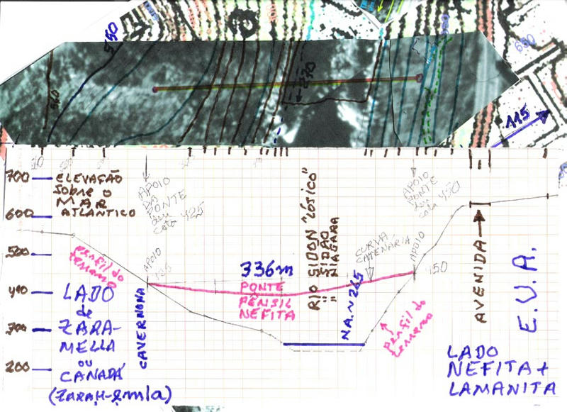
Press again the "minus" and already you can see the ISTHMUS of NIAGARA, at your right, which is ZARAHEMLA KINGDOM.
Press onece more the "minus" and you can see perfectly the land of the ISTHMUS NIAGARA, which is the KINGDOM ZARAHEMLA, at the CANADA side in relation to the NIAGARA FALLS. You can see some "dividing water" (SIDON RIVER, NIAGARA RIVER) flowing through a WILDERNESS separating the Zarahemla to the kingdoms of Nephites and Lamanites sited to the right side of the wilderness, which is the USA site. If you pay attention, there is a BLACK LINE joining the towns DETROIT = MANTI and BUFFALO (there is a Nephitic town for it, to be disclosed latter, a great battle took place there). Such black line is the deepest of WEST SEA = Lake Erie, the position in which, for legal purposes and for environmental reasons, is FLOWING THE "SIDON RIVER" lenthic condition. Thus in fact in modernity there is no more such thing as "LAKE ERIE" but RIVER SIDON "LENTHIC". The legal boundary to separate counties, states and nations is the position of the River flowing in the "Lenthic condition" under a lake and reservoirs.
Let us see one such link for other things to examine in Alma 22:27-33.
http://LDS.org/scriptures/Book of Mormon/alma/22.27,29?lang=eng
27 And it came to pass that the king sent a proclamation throughout all the land, amongst all his people who were in all his land, who were in all the regions round about, which was bordering even to the sea, on the east and on the west, and which was divided from the land of Zarahemla by a narrow strip of wilderness, which ran from the sea east even to the sea west, and round about on the borders of the seashore, and the borders of the wilderness which was on the north by the land of Zarahemla, through the borders of Manti, by the head of the river Sidon, running from the east towards the west—and thus were the Lamanites and the Nephites divided.
(we already saw this flow east toward west, above, using Google maps).
28 Now, the more idle part of the Lamanites lived in the wilderness, and dwelt in tents; and they were spread through the wilderness on the west, in the land of Nephi; yea, and also on the west of the land of Zarahemla, in the borders by the seashore, and on the west in the land of Nephi, in the place of their fathers’ first inheritance, and thus bordering along by the seashore.
29 And also there were many Lamanites on the east by the seashore, whither the Nephites had driven them. And thus the Nephites were nearly surrounded by the Lamanites; nevertheless the Nephites had taken possession of all the northern parts of the land bordering on the wilderness, at the head of the river Sidon, from the east to the west, round about on the wilderness side; on the north, even until they came to the land which they called Bountiful.
30 And it bordered upon the land which they called Desolation, it being so far northward that it came into the land which had been peopled and been destroyed, of whose bones we have spoken, which was discovered by the people of Zarahemla, it being the place of their first landing.
31 And they came from there up into the south wilderness. Thus the land on the northward was called Desolation, and the land on the southward was called Bountiful, it being the wilderness which is filled with all manner of wild animals of every kind, a part of which had come from the land northward for food.
32 And now, it was only the distance of a day and a half’s journey for a Nephite, on the line Bountiful and the land Desolation, from the east to the west sea; and thus the land of Nephi and the land of Zarahemla were nearly surrounded by water, there being a small neck of land between the land northward and the land southward.
33 And it came to pass that the Nephites had inhabited the land Bountiful, even from the east unto the west sea, and thus the Nephites in their wisdom, with their guards and their armies, had hemmed in the Lamanites on the south, that thereby they should have no more possession on the north, that they might not overrun the land northward.
We already investigated the land of MANTI and nearby/around it. We could see how closely linked MANTI was to ZARAHEMLA, quite like being a natural extension because of the close geographic proximity and easy of military attacks from Zarahemla. We are to examine some features of MANTI while linking to Zarahemla and to the Jaredites.
MANTI was a place ultra-important in the military strategy and economic trade place for Nephitic empire, because of its ultra-strategic position. Quite like that of Constantinople in the link between Europe and Asia. It is very evident that all trade from Zarahemla and from Nephites harbor to "head of Sidon River" (which is nowadays Chicago town, also the harbor for trade toward the Gulf of Mexico through Illinois River = West Sidon River branch) had to be controlled through the military town of MANTI.
Get into the Google Map:
http://maps.google.com/
In the box "maps", type in: Lake Tacoma, Detroit, MI, United States
Press enter and you will see the Sidon River (Detroit River) flowing from EAST to WEST (your horizontal direction), as stated in the Book of Mormon, for NEARBY MANTI town. What is valid is the MAIN FLOW, the one used to stablish (set) the boundaries between the USA and CANADA. That is the "LEGAL" flow. The others are not considered. In any way the general flow direction of SIDON RIVER while passing through the region of MANTI TOWN is from EAST(ern) direction to the WEST(ern) direction, toward the SEA (WEST SEA) = Lake Erie.
In the left side, there is a "vertical bar" for the control of elevation. At the down part of the bar, there is a square with the minus signal (-) into it. Press it 1 times. See the result the pathway of Sidon River through the MANTI town and region (metropolitan area of Detroit). Repeat again for more 4 times. You can see that the GENERAL FLOW PATHWAY through MANTI TOWN and NEARBY IT is reasonably in the horizontal direction, thus from EAST to WEST DIRECTION.
Press again the "minus" and already you can see the ISTHMUS of NIAGARA, at your right, which is ZARAHEMLA KINGDOM.
Press onece more the "minus" and you can see perfectly the land of the ISTHMUS NIAGARA, which is the KINGDOM ZARAHEMLA, at the CANADA side in relation to the NIAGARA FALLS. You can see some "dividing water" (SIDON RIVER, NIAGARA RIVER) flowing through a WILDERNESS separating the Zarahemla to the kingdoms of Nephites and Lamanites sited to the right side of the wilderness, which is the USA site. If you pay attention, there is a BLACK LINE joining the towns DETROIT = MANTI and BUFFALO (there is a Nephitic town for it, to be disclosed latter, a great battle took place there). Such black line is the deepest of WEST SEA = Lake Erie, the position in which, for legal purposes and for environmental reasons, is FLOWING THE "SIDON RIVER" lenthic condition. Thus in fact in modernity there is no more such thing as "LAKE ERIE" but RIVER SIDON "LENTHIC". The legal boundary to separate counties, states and nations is the position of the River flowing in the "Lenthic condition" under a lake and reservoirs.
Let us see one such link for other things to examine in Alma 22:27-33.
http://LDS.org/scriptures/Book of Mormon/alma/22.27,29?lang=eng
27 And it came to pass that the king sent a proclamation throughout all the land, amongst all his people who were in all his land, who were in all the regions round about, which was bordering even to the sea, on the east and on the west, and which was divided from the land of Zarahemla by a narrow strip of wilderness, which ran from the sea east even to the sea west, and round about on the borders of the seashore, and the borders of the wilderness which was on the north by the land of Zarahemla, through the borders of Manti, by the head of the river Sidon, running from the east towards the west—and thus were the Lamanites and the Nephites divided.
(we already saw this flow east toward west, above, using Google maps).
28 Now, the more idle part of the Lamanites lived in the wilderness, and dwelt in tents; and they were spread through the wilderness on the west, in the land of Nephi; yea, and also on the west of the land of Zarahemla, in the borders by the seashore, and on the west in the land of Nephi, in the place of their fathers’ first inheritance, and thus bordering along by the seashore.
29 And also there were many Lamanites on the east by the seashore, whither the Nephites had driven them. And thus the Nephites were nearly surrounded by the Lamanites; nevertheless the Nephites had taken possession of all the northern parts of the land bordering on the wilderness, at the head of the river Sidon, from the east to the west, round about on the wilderness side; on the north, even until they came to the land which they called Bountiful.
30 And it bordered upon the land which they called Desolation, it being so far northward that it came into the land which had been peopled and been destroyed, of whose bones we have spoken, which was discovered by the people of Zarahemla, it being the place of their first landing.
31 And they came from there up into the south wilderness. Thus the land on the northward was called Desolation, and the land on the southward was called Bountiful, it being the wilderness which is filled with all manner of wild animals of every kind, a part of which had come from the land northward for food.
32 And now, it was only the distance of a day and a half’s journey for a Nephite, on the line Bountiful and the land Desolation, from the east to the west sea; and thus the land of Nephi and the land of Zarahemla were nearly surrounded by water, there being a small neck of land between the land northward and the land southward.
33 And it came to pass that the Nephites had inhabited the land Bountiful, even from the east unto the west sea, and thus the Nephites in their wisdom, with their guards and their armies, had hemmed in the Lamanites on the south, that thereby they should have no more possession on the north, that they might not overrun the land northward.


