I agree that Shulem has done a great job. I'd love to see it in a dialogue or sunstone article.Doctor CamNC4Me wrote: ↑Thu Jan 27, 2022 6:23 pmIt’s pretty clear Joseph Smith’s story is a pastiche of sources and places he had access to. What I love about the DRT is how it connects to Joseph Smith’s plagiarism of the Late War. You can see he copped meta material from View of the Hebrews, the narrative framework of the Late War, and inserted place names from his in real life experiences. A LGT doesn’t have to reflect a hard reality any more than Westeros has to connect to the British Isles as a perfect geographic match. But it sure is helpful to see what Joseph Smith had in his mind’s eye when writing Alma, for example. What Shulem’s leg work here has done for me, at least, is to put everything into sharp relief.Dr Exiled wrote: ↑Thu Jan 27, 2022 6:11 pmI think there is no doubt the thing was made up. However, what inspired the geography in the fiction book is an interesting question. It's interesting because so many still cling to literalness when there isn't proof for it.
As fiction writers sometimes get inspired by surroundings, the same must have happened to Joseph Smith. I like Shulem's theory and how the Delaware area fits. The finger lakes fit too in some respects and it is closer to Joseph Smith. However, perhaps there was a decided effort to place the story somewhere else to keep people off of the scent? Having the story take place not so close would avoid claims that Joseph Smith just looked outside of his house and used that for his fiction book? I don't know what motivated the guy and more historical evidence is needed.
- Doc
"Finger Lakes" Theory of Book of Mormon Geography
-
Dr Exiled
- God
- Posts: 2249
- Joined: Tue Oct 27, 2020 2:40 pm
Re: "Finger Lakes" Theory of Book of Mormon Geography
Myth is misused by the powerful to subjugate the masses all too often.
-
Shulem

- God
- Posts: 8775
- Joined: Wed Oct 28, 2020 1:40 am
- Location: Facsimile No. 3
Re: "Finger Lakes" Theory of Book of Mormon Geography
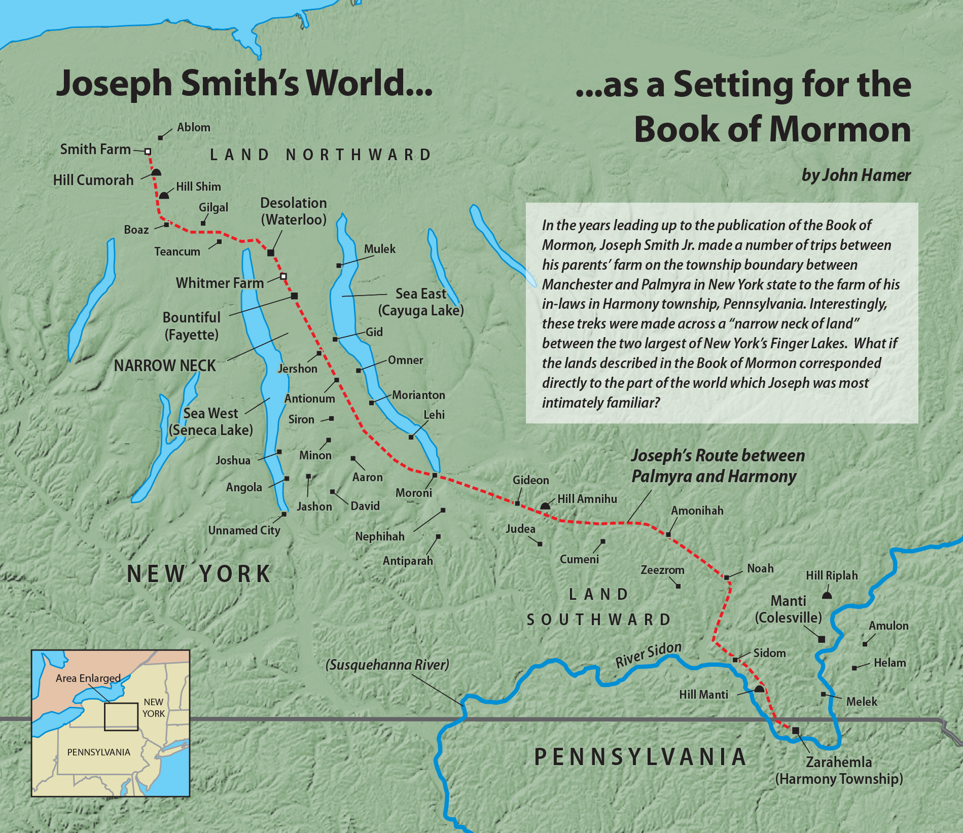
According to the map and labels in the above map it simply isn't possible because Sea West doesn't feed into the Susquehanna river. Hagoth sailed into Sea West and proceeded north into the land. That's not possible in the above map.
-
Shulem
- God
- Posts: 8775
- Joined: Wed Oct 28, 2020 1:40 am
- Location: Facsimile No. 3
Re: "Finger Lakes" Theory of Book of Mormon Geography
Thank you so much for your vote of confidence. Indeed, I think you can see that I've stumbled on a winning scenario that really works. This message board will serve as the jumping off point and soundboard to anyone who wants to take matters up and write something. All roads lead back to Discuss Mormonism when it comes to Delmarva which I believe will become a hot topic as more people grasp the concepts I've been pushing.
-
Moksha

- God
- Posts: 8266
- Joined: Wed Oct 28, 2020 3:13 am
- Location: Koloburbia
Re: "Finger Lakes" Theory of Book of Mormon Geography
If the FAIR Conference of 2022, held in the Algae Bloom Arena of the Utah Lake Visitor Center, wanted a true game-changer they would have Paul present his Delmarva findings.
Cry Heaven and let loose the Penguins of Peace
-
Shulem
- God
- Posts: 8775
- Joined: Wed Oct 28, 2020 1:40 am
- Location: Facsimile No. 3
Re: "Finger Lakes" Theory of Book of Mormon Geography
It would be a game-changer, that's for sure. The narrow neck has become the Abrahamic "King's Name" for the Book of Mormon.
Book of Mormon apologists have a whole new set of problems on their hands compliments of me. And, I have not showed all my cards yet! I've got aces up my sleeve, baby. Put all your money on me. It's a sure bet.
-
Moksha
- God
- Posts: 8266
- Joined: Wed Oct 28, 2020 3:13 am
- Location: Koloburbia
Re: "Finger Lakes" Theory of Book of Mormon Geography
You've found the missing 116 pages, Amelia Earhardt, and Judge Crater!
Cry Heaven and let loose the Penguins of Peace
-
Kishkumen

- God
- Posts: 10410
- Joined: Tue Oct 27, 2020 2:37 pm
- Location: Cassius University
- Contact:
Re: "Finger Lakes" Theory of Book of Mormon Geography
Thanks to John Hamer for dropping by and sharing this fascinating theory! I have always wondered how the Finger Lakes might fit into Book of Mormon geography, and I hope we see him flesh out this theory a lot more. I had always assumed that the Great Lakes were providing the waters surrounding the Narrow Neck. The two Finger Lakes suggestion is especially interesting to me because my ancestors lived on Cayuga Lake.
"He disturbs the laws of his country, he forces himself upon women, and he puts men to death without trial.” ~Otanes on the monarch, Herodotus Histories 3.80.
-
Kishkumen
- God
- Posts: 10410
- Joined: Tue Oct 27, 2020 2:37 pm
- Location: Cassius University
- Contact:
Re: "Finger Lakes" Theory of Book of Mormon Geography
I am going to take partial exception to your statement. I think there is a huge difference between trying to establish an ancient Book of Mormon geography situated in Mesoamerica and speculating about the environmental influences that might have inspired Joseph Smith as he was writing the Book of Mormon. For one thing, we know which hill Joseph Smith identified as Cumorah. Period. Therefore, to try to form the map around the site he personally identified and claimed to have found the plates in is a speculative exercise, to be sure, but it is also one that proceeds from the reasonable supposition that the placement of other sites in the Book of Mormon would be relative to the one that we know Smith identified.Is this idea fun and clever? Sure. Does it have any explanatory value in understanding the Book of Mormon. No. What are the chances that Joseph Smith had this map in mind when composing the Book of Mormon? Zero. None of the limited geography theories have any historical merit and this is no different. In posting this, will someone somewhere now believe this is the real map? Yes, because we are in a post-truth, post-expertise universe where people imagine that individual "belief" alone is meaningful.
I am all for methodological care, but your statement goes too far for my taste. Because we have not seen a good argument, supported by evidence, for the inspiration for Joseph Smith’s Book of Mormon “geography” does not mean there is not one to be found, and it could be that some version of your fun speculative object lesson turns out to be the one. On the other hand, it may be that Smith did not keep a single schema in mind. That hypothesis, too, should be demonstrated with evidence and argumentation, not just assumed.
Finally, this post-truth stuff is silly. At what time were people not prepared to believe all kinds of goofy stuff? I can guarantee that there is no danger of Book of Mormon geography running amok in our “post-truth age” like Q and other nonsense. It just has no bearing on the concerns of most people, even the unhinged. Book of Mormon geography has always been, for the most part, a hobby for people with way too much time on their hands.
In any case, thanks for your fun speculation, which was exactly that. I have no problem with fun speculations, and very many silly beliefs do not have a dire impact. Rather, I enjoy fun speculations, and I am amused and intrigued by the odd beliefs of others. They will always exist, and they provide just one more window on the human organism.
"He disturbs the laws of his country, he forces himself upon women, and he puts men to death without trial.” ~Otanes on the monarch, Herodotus Histories 3.80.
-
Shulem
- God
- Posts: 8775
- Joined: Wed Oct 28, 2020 1:40 am
- Location: Facsimile No. 3
Re: "Finger Lakes" Theory of Book of Mormon Geography
John Hamer wrote: ↑Thu Jan 27, 2022 3:46 pm
The bulk of the Book of Mormon narrative takes place in a region around the city of Zarahemla, which is “southward” from the Hill Cumorah, across a “narrow neck of land” separated by two seas (east and west). Given the fact that the Hill Cumorah is the only site in the text that was explicitly identified by the author at the time of the book's composition, it is interesting to note that a “narrow neck of land” between two bodies of water (east and west) does exist just to the hill’s southeast. This neck is the isthmus formed by Seneca Lake and Cayuga Lake — the two largest of New York’s Finger Lakes. These two freshwater lakes are both approximately the same size as the freshwater lake which the Bible names the “Sea of Galilee.” Seneca Lake has a surface area of 67 square miles; Cayuga Lake and the Sea of Galilee both have a surface area of 64 square miles. The Book of Mormon never uses the term “lake” to refer to a body of water, and so we might plausibly identify these lakes as Book of Mormon “seas.”
John,
You've not asked anyone here to critique your map or provide input or advice which I am capable of providing, so I've put off saying much. But I simply can't resist pointing out that your Zarahemla is an exceedingly great distance away from the narrow neck compared to the distance of the narrow neck from the large body of water to the north, Lake Ontario. Milage given in the Book of Mormon shows the reverse in as much as it is the large bodies of water to the north of the neck are an exceedingly great distance to the north, not just some 20 miles and certainly not any closer than Zarahemla which is in the center of the landmass to the south.
Just saying, I don't mean to be rude, but the map you provide as it corresponds with the text in the Book of Mormon is absurd and retarded. Sorry if that is offensive but I needed to say it as I see it.
Last edited by Shulem on Tue Feb 01, 2022 4:37 pm, edited 2 times in total.
-
Shulem
- God
- Posts: 8775
- Joined: Wed Oct 28, 2020 1:40 am
- Location: Facsimile No. 3
Re: "Finger Lakes" Theory of Book of Mormon Geography
John Hamer wrote: ↑Thu Jan 27, 2022 3:46 pmThis neck is the isthmus formed by Seneca Lake and Cayuga Lake — the two largest of New York’s Finger Lakes. These two freshwater lakes are both approximately the same size as the freshwater lake which the Bible names the “Sea of Galilee.” Seneca Lake has a surface area of 67 square miles; Cayuga Lake and the Sea of Galilee both have a surface area of 64 square miles. The Book of Mormon never uses the term “lake” to refer to a body of water, and so we might plausibly identify these lakes as Book of Mormon “seas.”
It's true that the word "lake" is not found in the Book of Mormon. Instead, we are given large bodies of water which seem to be descriptive of lakes. Now, it's impossible that the seas to the west and east of the narrow neck are fresh water bodies contained within themselves on land not being fluid with the ocean. Impossible! The Book of Mormon narrative explains that the land to include Bountiful, Zarahemla, land of Nephi, and Lehi's first inheritance were nearly surrounded by water and that the only way out was through the narrow neck.
Joseph Smith via Nephi said, "we have been led to a better land, for the Lord has made the sea our path, and we are upon an isle of the sea" and that "sea" which was their path across the ocean was the great brine as was the seas surrounding Nephi's "isle" with ocean water.