"Finger Lakes" Theory of Book of Mormon Geography
Posted: Thu Jan 27, 2022 3:46 pm
When Joseph Smith obtained the golden plates at the Hill Cumorah on September 22, 1827, he and his wife Emma were living nearby on his parents’ farm on the border between the townships of Manchester and Palmyra, New York. That December, the couple moved to Emma’s parents’ farm in Harmony, Pennsylvania. The plates came with them, said to be hidden in a barrel of beans. Joseph began the process of translation that winter, with Emma acting as his principle scribe. In April of 1828, Martin Harris of Palmyra arrived in Harmony and took over the role of scribe. By that June, Joseph was persuaded to allow Martin to take the first 116 pages of the manuscript back to Palmyra. In July, Joseph joined Martin in Palmyra and learned that the manuscript had been lost. This ended work on the translation for several months as Joseph returned to farming in Harmony. Translation began again by the winter of 1828-29 at the point the text had reached prior the loss of the 116 pages, with Emma and Samuel Smith acting as scribes. In April of 1829, Oliver Cowdery, who had been living with Joseph’s parents, traveled from Manchester to Harmony. Along the way, Oliver visited the Whitmer family in Fayette, New York. (He had met David Whitmer the year before in Palmyra.) Arriving in Harmony, Oliver took over as Joseph’s principle scribe and the pace of translation quickened appreciably. By the end of May, Joseph came to the conclusion of what would become the Book of Mormon and began the translation of the book’s beginning section which would replace the lost 116 pages. At the beginning of June, David Whitmer arrived in Harmony to help Joseph, Emma and Oliver move from Harmony to the Whitmer farm in Fayette. Shortly after establishing himself in Fayette, Joseph traveled to Palmyra where he and Martin Harris proposed that local printer Egbert Grandin publish the forthcoming Book of Mormon. By mid-June, Joseph was back in Fayette and the work of translation was completed by early July, and by August the printing of the Book of Mormon had begun. What if the geography of the Book of Mormon was likewise inspired by the locations surrounding Joseph’s life during the translation?
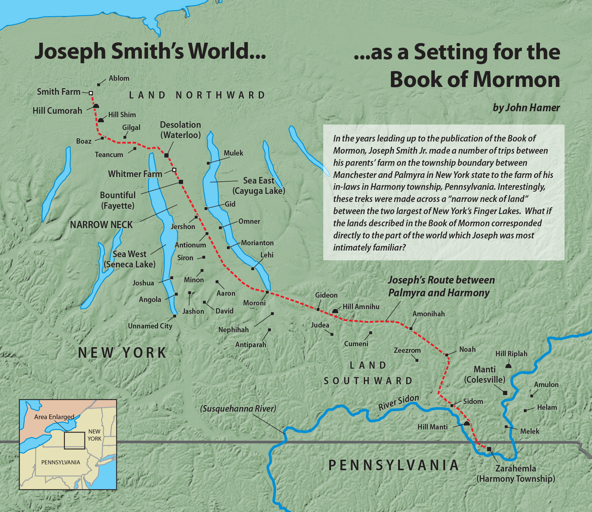
The bulk of the Book of Mormon narrative takes place in a region around the city of Zarahemla, which is “southward” from the Hill Cumorah, across a “narrow neck of land” separated by two seas (east and west). Given the fact that the Hill Cumorah is the only site in the text that was explicitly identified by the author at the time of the book's composition, it is interesting to note that a “narrow neck of land” between two bodies of water (east and west) does exist just to the hill’s southeast. This neck is the isthmus formed by Seneca Lake and Cayuga Lake — the two largest of New York’s Finger Lakes. These two freshwater lakes are both approximately the same size as the freshwater lake which the Bible names the “Sea of Galilee.” Seneca Lake has a surface area of 67 square miles; Cayuga Lake and the Sea of Galilee both have a surface area of 64 square miles. The Book of Mormon never uses the term “lake” to refer to a body of water, and so we might plausibly identify these lakes as Book of Mormon “seas.”
It is also intriguing to note that the most direct route between Palmyra, New York and Harmony, Pennsylvania crosses the isthmus between Seneca Lake and Cayuga Lake, and that Joseph would have crossed it many times in the course of his translation work. Taking this correlation southward, it is tempting to identify the Book of Mormon’s principle city, Zarahemla, with the farm of Joseph’s in-laws, the Hales. In the text, Zarahemla is set near a river, called the Sidon. The Hales’ farm was located near one of the largest rivers in the area, the Susquehanna. The Book of Mormon does not describe the outlet of the River Sidon, which seems to be outside the area of its principle narrative. The Susquehanna’s outlet in Maryland was certainly outside the range of Joseph’s experience. The text does describe the important city of Manti, which was up the River Sidon from Zarahemla. It is again tempting to link this city with the area around Colesville and South Bainbridge, New York — home of Joseph’s frequent benefactor, Joseph Knight.
_________________
Is this idea fun and clever? Sure. Does it have any explanatory value in understanding the Book of Mormon. No. What are the chances that Joseph Smith had this map in mind when composing the Book of Mormon? Zero. None of the limited geography theories have any historical merit and this is no different. In posting this, will someone somewhere now believe this is the real map? Yes, because we are in a post-truth, post-expertise universe where people imagine that individual "belief" alone is meaningful.