Kingdom ZARAHEMLA since land of MANTI. Separated by SIDON
We already investigated the land of MANTI and nearby/around it. We could see how closely linked MANTI was to ZARAHEMLA, quite like being a natural extension because of the close geographic proximity and easy of military attacks from Zarahemla. We are to examine some features of MANTI while linking to Zarahemla and to the Jaredites.
MANTI was a place ultra-important in the military strategy and economic trade place for Nephitic empire, because of its ultra-strategic position. Quite like that of Constantinople in the link between Europe and Asia. It is very evident that all trade from Zarahemla and from Nephites harbor to "head of Sidon River" (which is nowadays Chicago town, also the harbor for trade toward the Gulf of Mexico through Illinois River = West Sidon River branch) had to be controlled through the military town of MANTI.
Get into the Google Map:
http://maps.google.com/
In the box "maps", type in: Lake Tacoma, Detroit, MI, United States
Press enter and you will see the Sidon River (Detroit River) flowing from EAST to WEST (your horizontal direction), as stated in the Book of Mormon, for NEARBY MANTI town. What is valid is the MAIN FLOW, the one used to stablish (set) the boundaries between the USA and CANADA. That is the "LEGAL" flow. The others are not considered. In any way the general flow direction of SIDON RIVER while passing through the region of MANTI TOWN is from EAST(ern) direction to the WEST(ern) direction, toward the SEA (WEST SEA) = Lake Erie.
In the left side, there is a "vertical bar" for the control of elevation. At the down part of the bar, there is a square with the minus signal (-) into it. Press it 1 times. See the result the pathway of Sidon River through the MANTI town and region (metropolitan area of Detroit). Repeat again for more 4 times. You can see that the GENERAL FLOW PATHWAY through MANTI TOWN and NEARBY IT is reasonably in the horizontal direction, thus from EAST to WEST DIRECTION.
Press again the "minus" and already you can see the ISTHMUS of NIAGARA, at your right, which is ZARAHEMLA KINGDOM.
Press onece more the "minus" and you can see perfectly the land of the ISTHMUS NIAGARA, which is the KINGDOM ZARAHEMLA, at the CANADA side in relation to the NIAGARA FALLS. You can see some "dividing water" (SIDON RIVER, NIAGARA RIVER) flowing through a WILDERNESS separating the Zarahemla to the kingdoms of Nephites and Lamanites sited to the right side of the wilderness, which is the USA site. If you pay attention, there is a BLACK LINE joining the towns DETROIT = MANTI and BUFFALO (there is a Nephitic town for it, to be disclosed latter, a great battle took place there). Such black line is the deepest of WEST SEA = Lake Erie, the position in which, for legal purposes and for environmental reasons, is FLOWING THE "SIDON RIVER" lenthic condition. Thus in fact in modernity there is no more such thing as "LAKE ERIE" but RIVER SIDON "LENTHIC". The legal boundary to separate counties, states and nations is the position of the River flowing in the "Lenthic condition" under a lake and reservoirs.
Let us see one such link for other things to examine in Alma 22:27-33.
http://LDS.org/scriptures/Book of Mormon/alma/22.27,29?lang=eng
27 And it came to pass that the king sent a proclamation throughout all the land, amongst all his people who were in all his land, who were in all the regions round about, which was bordering even to the sea, on the east and on the west, and which was divided from the land of Zarahemla by a narrow strip of wilderness, which ran from the sea east even to the sea west, and round about on the borders of the seashore, and the borders of the wilderness which was on the north by the land of Zarahemla, through the borders of Manti, by the head of the river Sidon, running from the east towards the west—and thus were the Lamanites and the Nephites divided.
(we already saw this flow east toward west, above, using Google maps).
28 Now, the more idle part of the Lamanites lived in the wilderness, and dwelt in tents; and they were spread through the wilderness on the west, in the land of Nephi; yea, and also on the west of the land of Zarahemla, in the borders by the seashore, and on the west in the land of Nephi, in the place of their fathers’ first inheritance, and thus bordering along by the seashore.
29 And also there were many Lamanites on the east by the seashore, whither the Nephites had driven them. And thus the Nephites were nearly surrounded by the Lamanites; nevertheless the Nephites had taken possession of all the northern parts of the land bordering on the wilderness, at the head of the river Sidon, from the east to the west, round about on the wilderness side; on the north, even until they came to the land which they called Bountiful.
30 And it bordered upon the land which they called Desolation, it being so far northward that it came into the land which had been peopled and been destroyed, of whose bones we have spoken, which was discovered by the people of Zarahemla, it being the place of their first landing.
31 And they came from there up into the south wilderness. Thus the land on the northward was called Desolation, and the land on the southward was called Bountiful, it being the wilderness which is filled with all manner of wild animals of every kind, a part of which had come from the land northward for food.
32 And now, it was only the distance of a day and a half’s journey for a Nephite, on the line Bountiful and the land Desolation, from the east to the west sea; and thus the land of Nephi and the land of Zarahemla were nearly surrounded by water, there being a small neck of land between the land northward and the land southward.
33 And it came to pass that the Nephites had inhabited the land Bountiful, even from the east unto the west sea, and thus the Nephites in their wisdom, with their guards and their armies, had hemmed in the Lamanites on the south, that thereby they should have no more possession on the north, that they might not overrun the land northward.
Kingdom ZARAHEMLA since land of MANTI. Separated by SIDON
-
_ELYSAB
- _Emeritus
- Posts: 189
- Joined: Thu Aug 18, 2011 10:54 pm
-
_ELYSAB
- _Emeritus
- Posts: 189
- Joined: Thu Aug 18, 2011 10:54 pm
Re: Kingdom ZARAHEMLA since land of MANTI. Separated by SIDON
The small enlarged image is presented next. But if the person is interested in see better details, please click on next URL to see better details.

Here is the URL of the image very much enlarged. Click on next URL.
http://www.mediafire.com/imgbnc.php/3420407d2e6951e47d23c89f0ee66a3e6475e79c45c11eabd77181f4b56c8e916g.jpg
If you want even more details from the image obtained from above URL, you may save the image and use a program that allow enlarging images, as the Paint or the Picture Manager (from the Microsoft) etc.
The above drawing is only good for some limited purpose, in quite large scale. In reduce scale, as able to show simultaneously the Isthmus of Niagara and both West and East Sea (Erie Lake and Ontario Lake, in full), other map will be required, as for troops movements and battles. Then we have battle grounds of some interesting cases quite like of Nephites x Lamanites on Buffalo...
Let us see one such link for other things to examine in Alma 22:27-33 in relation to Isthmus of Niagara (among other things).
http://LDS.org/scriptures/Book of Mormon/alma/22.27,29?lang=eng
reason that ZARAHEMLA = CANADA and USA = NEPHITES
27 And it came to pass that the king sent a proclamation throughout all the land, amongst all his people who were in all his land, who were in all the regions round about (THUS NOT ONLY IN ZARAEMLA, BUT IN NEARBY LANDS), which was bordering even to the sea, on the east and on the west, (ALL NATIONS AROUND LAKE ERIE AND ONTARIUM) and (the nation =USA = NEPHIs) which was divided from the land of Zarahemla=CANADA by a narrow strip of wilderness = THAT BUSHES WITH THE RIVER NIAGARA=SIDON PASSING AMONG THEM in the deep canyon,
which (NARROW STRIP=Niagara river=Sidon river with bushes) ran from the sea east (ONTARIO Lake) even to the sea west (ERIE LAKE), and (the RIVER SIDON Lenthic is flowing) round about on the borders of the seashore (on both side of the Isthmus: see map), and (Sidon river is flowing in) the borders of the wilderness (margin of lake Erie) which was on the north by the land of Zarahemla, (and such truth continue) through the borders of Manti, (and continues) by the head of the river Sidon (which is in CHICAGO), (THAT IN CHICAGO IS) running from the east towards the west—and thus were the Lamanites and the Nephites divided (BECAUSE THE LAMANITES COULD NEVER ENTER INTO THE NORTH PART, IN WHICH THE SIDON RIVER FLOWS FROM EAST TO WEST: in the north of MANTI...).
(We already saw the flow east toward west, above, using Google maps).

http://www.mediafire.com/imgbnc.php/97f5f51fb4b6037384a6e40c31ca846e6015cfbbee61a5cbdff5e2960f073d606g.jpg
If you want previous image enlarged, click on this URL.
28 Now, the more idle part of the Lamanites lived in the wilderness, and dwelt in tents; and they were spread through the wilderness on the west, in the land of Nephi; yea, and also on the west of the land of Zarahemla, in the borders by the seashore, and on the west in the land of Nephi, in the place of their fathers’ first inheritance, and thus bordering along by the seashore. It is saying the lamanites were living in front of Cumorah, in the other side of the Lake Ontario. The other extremity of lamanites, in lad of Zarahemla, is shown in the above map, in the upper left corner, above Hamilton town. We need a map in a smaller scale.
29 And also there were many Lamanites on the east by the seashore, whither the Nephites had driven them. And thus the Nephites were nearly surrounded by the Lamanites; nevertheless the Nephites had taken possession of all the northern parts of the land bordering on the wilderness, at the head of the river Sidon, from the east to the west, round about on the wilderness side; THUS ALL LAKE MICHIGAN WAS UNDER DOMAIN OF NEPHITES. On the north, even until they came to the land which they called Bountiful. ---> MANTI
30 And it bordered upon the land which they called Desolation (LAKE MICHIGAN), it being so far northward that it came into the land which had been peopled BY JAREDITES and been destroyed, of whose bones (OF JAREDITES) we have spoken, which was discovered by the people of Zarahemla, it (isthmus of Zaraemla) being the place of their first landing.
31 And they came from there up into the south wilderness. Thus the land on the northward was called Desolation, and the land on the southward (of MANTI) was called Bountiful, it being the wilderness which is filled with all manner of wild animals of every kind, a part of which had come from the land northward for food.
OTHER SUBJECT AND OTHER TIME. A BREAK IN TIME. OTHER ACCOUNT.
32 And now, it was only the distance of a day and a half’s journey for a Nephite, on the line Bountiful ("other" BOUNTIFUL, bountiful a generic ECOLOGIC name) and the land Desolation, from the east (EAST SEA, FRESH H water SEA as GALILEE SEA, LAKE ONTARIUM) to the west sea (lake ERIE); and thus the land of Nephi = USA and the land of Zarahemla = CANADA were nearly surrounded by water,
There being a small neck of land between the land northward and the land southward. I DON'T KNOW HOW IT IS. IT IS SOMETHING IN MANTI, WHERE WE HAVE THE "NECK" OF WATER SEPARATING WHAT IS PROBABLY LAND NORTHWARD AND SOUTHWARD, at the point where died so many lamanites trying to cross the Sidon river...
NOTICE that ZARAHEMLA was almost encircled by water, in 3 directions. By the Lake Ontario, by the Lake Erie and by the River Sidon (Niagara River). Thus Zarahemla was almost encircled by waters.
33 And it came to pass that the Nephites had inhabited the land Bountiful, even from the east unto the west sea, and thus the Nephites in their wisdom, with their guards and their armies, had hemmed in the Lamanites on the south, that thereby they should have no more possession on the north (of WEST SEA, LAKE ERIE, where they could obtain domain over MANTI and get control over the way for domain over the NORTH LANDS and WATERS: the region of LAKE MICHIGAN , that they might not overrun the land northward, where is head of Sidon River e nowadays Chicago.
Here is the URL of the image very much enlarged. Click on next URL.
http://www.mediafire.com/imgbnc.php/3420407d2e6951e47d23c89f0ee66a3e6475e79c45c11eabd77181f4b56c8e916g.jpg
If you want even more details from the image obtained from above URL, you may save the image and use a program that allow enlarging images, as the Paint or the Picture Manager (from the Microsoft) etc.
The above drawing is only good for some limited purpose, in quite large scale. In reduce scale, as able to show simultaneously the Isthmus of Niagara and both West and East Sea (Erie Lake and Ontario Lake, in full), other map will be required, as for troops movements and battles. Then we have battle grounds of some interesting cases quite like of Nephites x Lamanites on Buffalo...
Let us see one such link for other things to examine in Alma 22:27-33 in relation to Isthmus of Niagara (among other things).
http://LDS.org/scriptures/Book of Mormon/alma/22.27,29?lang=eng
reason that ZARAHEMLA = CANADA and USA = NEPHITES
27 And it came to pass that the king sent a proclamation throughout all the land, amongst all his people who were in all his land, who were in all the regions round about (THUS NOT ONLY IN ZARAEMLA, BUT IN NEARBY LANDS), which was bordering even to the sea, on the east and on the west, (ALL NATIONS AROUND LAKE ERIE AND ONTARIUM) and (the nation =USA = NEPHIs) which was divided from the land of Zarahemla=CANADA by a narrow strip of wilderness = THAT BUSHES WITH THE RIVER NIAGARA=SIDON PASSING AMONG THEM in the deep canyon,
which (NARROW STRIP=Niagara river=Sidon river with bushes) ran from the sea east (ONTARIO Lake) even to the sea west (ERIE LAKE), and (the RIVER SIDON Lenthic is flowing) round about on the borders of the seashore (on both side of the Isthmus: see map), and (Sidon river is flowing in) the borders of the wilderness (margin of lake Erie) which was on the north by the land of Zarahemla, (and such truth continue) through the borders of Manti, (and continues) by the head of the river Sidon (which is in CHICAGO), (THAT IN CHICAGO IS) running from the east towards the west—and thus were the Lamanites and the Nephites divided (BECAUSE THE LAMANITES COULD NEVER ENTER INTO THE NORTH PART, IN WHICH THE SIDON RIVER FLOWS FROM EAST TO WEST: in the north of MANTI...).
(We already saw the flow east toward west, above, using Google maps).
http://www.mediafire.com/imgbnc.php/97f5f51fb4b6037384a6e40c31ca846e6015cfbbee61a5cbdff5e2960f073d606g.jpg
If you want previous image enlarged, click on this URL.
28 Now, the more idle part of the Lamanites lived in the wilderness, and dwelt in tents; and they were spread through the wilderness on the west, in the land of Nephi; yea, and also on the west of the land of Zarahemla, in the borders by the seashore, and on the west in the land of Nephi, in the place of their fathers’ first inheritance, and thus bordering along by the seashore. It is saying the lamanites were living in front of Cumorah, in the other side of the Lake Ontario. The other extremity of lamanites, in lad of Zarahemla, is shown in the above map, in the upper left corner, above Hamilton town. We need a map in a smaller scale.
29 And also there were many Lamanites on the east by the seashore, whither the Nephites had driven them. And thus the Nephites were nearly surrounded by the Lamanites; nevertheless the Nephites had taken possession of all the northern parts of the land bordering on the wilderness, at the head of the river Sidon, from the east to the west, round about on the wilderness side; THUS ALL LAKE MICHIGAN WAS UNDER DOMAIN OF NEPHITES. On the north, even until they came to the land which they called Bountiful. ---> MANTI
30 And it bordered upon the land which they called Desolation (LAKE MICHIGAN), it being so far northward that it came into the land which had been peopled BY JAREDITES and been destroyed, of whose bones (OF JAREDITES) we have spoken, which was discovered by the people of Zarahemla, it (isthmus of Zaraemla) being the place of their first landing.
31 And they came from there up into the south wilderness. Thus the land on the northward was called Desolation, and the land on the southward (of MANTI) was called Bountiful, it being the wilderness which is filled with all manner of wild animals of every kind, a part of which had come from the land northward for food.
OTHER SUBJECT AND OTHER TIME. A BREAK IN TIME. OTHER ACCOUNT.
32 And now, it was only the distance of a day and a half’s journey for a Nephite, on the line Bountiful ("other" BOUNTIFUL, bountiful a generic ECOLOGIC name) and the land Desolation, from the east (EAST SEA, FRESH H water SEA as GALILEE SEA, LAKE ONTARIUM) to the west sea (lake ERIE); and thus the land of Nephi = USA and the land of Zarahemla = CANADA were nearly surrounded by water,
There being a small neck of land between the land northward and the land southward. I DON'T KNOW HOW IT IS. IT IS SOMETHING IN MANTI, WHERE WE HAVE THE "NECK" OF WATER SEPARATING WHAT IS PROBABLY LAND NORTHWARD AND SOUTHWARD, at the point where died so many lamanites trying to cross the Sidon river...
NOTICE that ZARAHEMLA was almost encircled by water, in 3 directions. By the Lake Ontario, by the Lake Erie and by the River Sidon (Niagara River). Thus Zarahemla was almost encircled by waters.
33 And it came to pass that the Nephites had inhabited the land Bountiful, even from the east unto the west sea, and thus the Nephites in their wisdom, with their guards and their armies, had hemmed in the Lamanites on the south, that thereby they should have no more possession on the north (of WEST SEA, LAKE ERIE, where they could obtain domain over MANTI and get control over the way for domain over the NORTH LANDS and WATERS: the region of LAKE MICHIGAN , that they might not overrun the land northward, where is head of Sidon River e nowadays Chicago.
-
_ELYSAB
- _Emeritus
- Posts: 189
- Joined: Thu Aug 18, 2011 10:54 pm
Re: Kingdom ZARAHEMLA since land of MANTI. Separated by SIDON
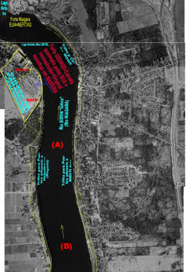
Here we are to provide some more information in relation to the kingdom of ZARAHEMLA and in relation to how it was linked to the Kingdom of the NEPHITES and LAMANITES, that was in the other side (to the west) of the SIDON River, or in the side where nowadays is the USA, with ZARAHEMLA being in the side where nowadays is the CANADA (Isthmus of NIAGARA), the borderline being Niagara River Lothic condition (Sidon River Lothic Condition).
http://www.mediafire.com/imgbnc.php/1fbf147aeaac36f374364c0ba9d18a3794c7da8a92d52d0737062197623fe06e6g.jpg
Click on the previous URL to see the image very much enlarged.

You can see the same image, very much enlarged (provided by the URL), now in its reduced image.
For what is the image?
Firs of all to show the connections between ZARAHEMLA and the kingdoms of Nephites, as the Jershom lands, in the lower part, downstream the waterfalls of Niagara (Sidon) River, section from such Falls to the East Sea (Ontario Lake). Pay attention that there were huge suspended bridges over the abyss of some 100m height, quite like yet in use in Peru (by the Inca Indians). Going upstream, in the town of Buffalo, we had ferocious battles between lamanites and Nefites for the control of the ultra-strategic town of AMNIU, which is a quite evident GREEK-SABELLIAN name, AMNIU = AM-N-IU = AM-IU (MN is from GREEK) = AMIU. At that time, many and many years ago, it was made an altimetric study of the battle ground that took place in Buffalo. It should be made condensed to be presented in web. It was used USGS maps for such studies. The text of Book of Mormon and the topographic map are in agreement.
You can see where is Bountiful (it is at the margins of Lake Ontario, the East Sea --- Because it was difficult and "expensive" to cut the forest and remove it for consumption around the West Sea and then around the North Sea, mainly around the LAKE MICHIGAN, mainly in its capital, which name is not provided, but it was CHICAGO...). Thus such region was PLENTY of ANIMAL LIFE and also of native vegetal species providing fruits for animals and humans. In the opposite, around the Lake Erie, which is WEST SEA, they had deforested, cut the TREES for transport them by the huge SAIL SHIP CARGO vessels (with some passengers) toward MANTI TOWN (nowadays Detroit) and then sailing toward SIDON RIVER lóthic condition (toward East Direction), then crossing Lake St. Clair, then moving to Lake Huron (North Sea) and then sailing to LAKE Michigan up to arriving into CHIGAGO with the precious wood THAT WAS TO MAKE HOUSES WITH WOOD. As nowadays Chicago originally was also made with wood BECAUSE OF THE TERRIBLE COLD WEATHER, very low temperature. But it also burned with terrible fires... Out of control. Only crazy persons would like to live in brick houses, in Chicago, or in Nephitic Kingdom declared by prophet Joseph Smith in the episode of ZELPH, the White Lamanite. They don't believe in their Prophet. Quite like cynics. Worst if they believe in living happy with brick made with cements... Nephites were unhappy, dreaming for the day of arrival of Hagoth's lumber from Zarahemla... Read the BOOK. Their DREAM was to have their houses in WOOD...
Look at the drawing. I guess that at the end of the narrowest length, the 1.5 day walking pathway from EAST SEA to the WEST SEA, in some 35 km walking most narrow "neck" land, in what direction it goes into water of Lake Ontario (East Sea), there I guess it is the place where it is submerged MORONI TOWN. Because for me, a Hydraulic and Marine Engineer, who worked with Erosion, it appears the place we have intense erosion. Probably great part of the disgraces is the result of big hurricane and consequent generation of big waves. They lived around rivers and lakes. As that material is Limestone, we may already have some caves that collapsed. As the town was over it, with the collapse of the cave (caused by waves like we saw in Japan), the Moroni town sank into EAST SEA. 3rd Nephi 8:9. The land southward is the south margin of the Ontarium Lake. Thus the strong hurricane wind was coming from the North direction. In 8:12 you can see that it was a "tempest=hurricane" and to be worst.
http://www.mediafire.com/imgbnc.php/1fbf147aeaac36f374364c0ba9d18a3794c7da8a92d52d0737062197623fe06e6g.jpg
Click on the previous URL to see the image very much enlarged.
You can see the same image, very much enlarged (provided by the URL), now in its reduced image.
For what is the image?
Firs of all to show the connections between ZARAHEMLA and the kingdoms of Nephites, as the Jershom lands, in the lower part, downstream the waterfalls of Niagara (Sidon) River, section from such Falls to the East Sea (Ontario Lake). Pay attention that there were huge suspended bridges over the abyss of some 100m height, quite like yet in use in Peru (by the Inca Indians). Going upstream, in the town of Buffalo, we had ferocious battles between lamanites and Nefites for the control of the ultra-strategic town of AMNIU, which is a quite evident GREEK-SABELLIAN name, AMNIU = AM-N-IU = AM-IU (MN is from GREEK) = AMIU. At that time, many and many years ago, it was made an altimetric study of the battle ground that took place in Buffalo. It should be made condensed to be presented in web. It was used USGS maps for such studies. The text of Book of Mormon and the topographic map are in agreement.
You can see where is Bountiful (it is at the margins of Lake Ontario, the East Sea --- Because it was difficult and "expensive" to cut the forest and remove it for consumption around the West Sea and then around the North Sea, mainly around the LAKE MICHIGAN, mainly in its capital, which name is not provided, but it was CHICAGO...). Thus such region was PLENTY of ANIMAL LIFE and also of native vegetal species providing fruits for animals and humans. In the opposite, around the Lake Erie, which is WEST SEA, they had deforested, cut the TREES for transport them by the huge SAIL SHIP CARGO vessels (with some passengers) toward MANTI TOWN (nowadays Detroit) and then sailing toward SIDON RIVER lóthic condition (toward East Direction), then crossing Lake St. Clair, then moving to Lake Huron (North Sea) and then sailing to LAKE Michigan up to arriving into CHIGAGO with the precious wood THAT WAS TO MAKE HOUSES WITH WOOD. As nowadays Chicago originally was also made with wood BECAUSE OF THE TERRIBLE COLD WEATHER, very low temperature. But it also burned with terrible fires... Out of control. Only crazy persons would like to live in brick houses, in Chicago, or in Nephitic Kingdom declared by prophet Joseph Smith in the episode of ZELPH, the White Lamanite. They don't believe in their Prophet. Quite like cynics. Worst if they believe in living happy with brick made with cements... Nephites were unhappy, dreaming for the day of arrival of Hagoth's lumber from Zarahemla... Read the BOOK. Their DREAM was to have their houses in WOOD...
Look at the drawing. I guess that at the end of the narrowest length, the 1.5 day walking pathway from EAST SEA to the WEST SEA, in some 35 km walking most narrow "neck" land, in what direction it goes into water of Lake Ontario (East Sea), there I guess it is the place where it is submerged MORONI TOWN. Because for me, a Hydraulic and Marine Engineer, who worked with Erosion, it appears the place we have intense erosion. Probably great part of the disgraces is the result of big hurricane and consequent generation of big waves. They lived around rivers and lakes. As that material is Limestone, we may already have some caves that collapsed. As the town was over it, with the collapse of the cave (caused by waves like we saw in Japan), the Moroni town sank into EAST SEA. 3rd Nephi 8:9. The land southward is the south margin of the Ontarium Lake. Thus the strong hurricane wind was coming from the North direction. In 8:12 you can see that it was a "tempest=hurricane" and to be worst.
-
_ELYSAB
- _Emeritus
- Posts: 189
- Joined: Thu Aug 18, 2011 10:54 pm
Re: Kingdom ZARAHEMLA since land of MANTI. Separated by SIDON
When the text is talking about the "disgraces" that took place at the northwest land, it is talking mainly at the north margin of EAST SEA and at the south margin of the WEST SEA, caused by the same intense wind and rain (hurricane) and some time of moderate quake. Thus probably Book of Mormon is talking mainly, in relation to the MANTI town (south margin of WEST SEA), in the place that where nowadays is metropolitan Detroit, the greatest one and most important town to keep safe (free of lamanites) the North Lands and Sea (mainly Michigan Lake and great Chicago of Book of Mormon days, to where the Great Hagoth's Sailships were going to, even whith great high priests...).
-
_ELYSAB
- _Emeritus
- Posts: 189
- Joined: Thu Aug 18, 2011 10:54 pm
Re: Kingdom ZARAHEMLA since land of MANTI. Separated by SIDON
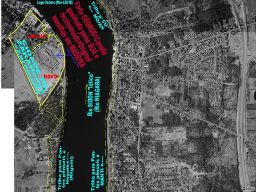
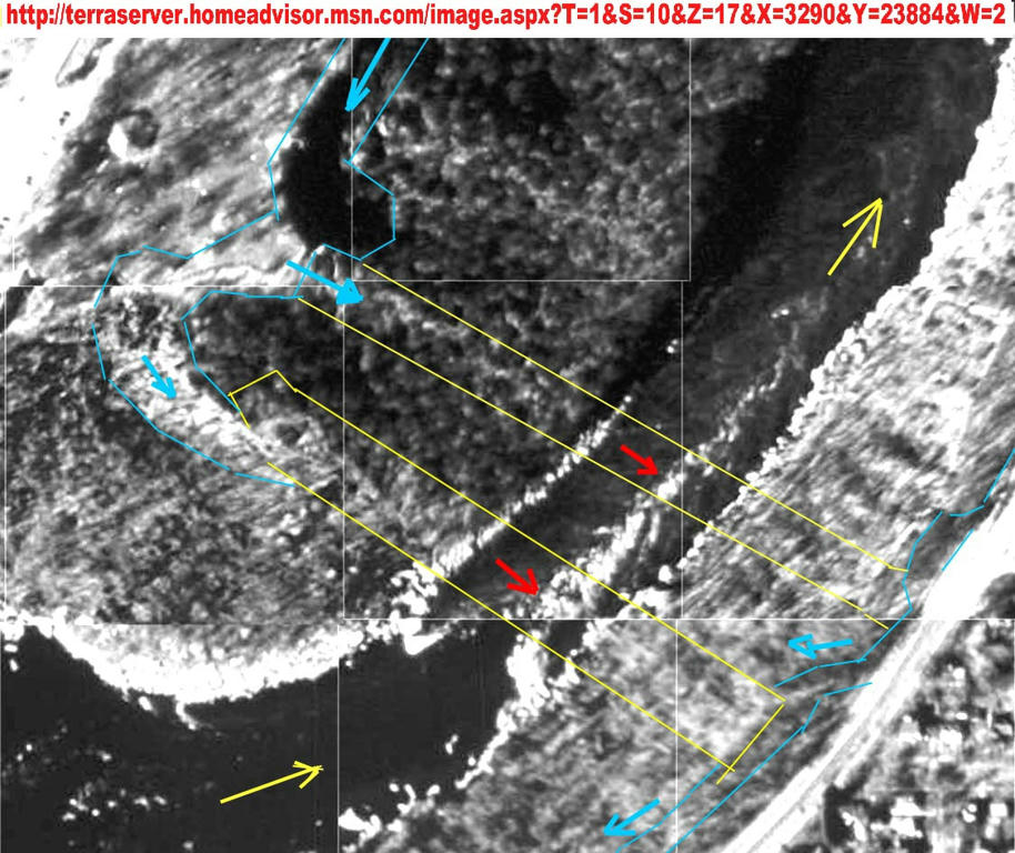
AMNIHU (nowadays BUFFALO) linking kingdom NEPHITES with ZARAHEMLA kingdom, just crossing the "gorge" of NIAGARA River (Sidon River): big BATTLES TOOK PLACE.
http://www.mediafire.com/imgbnc.php/a0dfec393998ee5b5df18f7463c1f080cd7146435014b4fee487e57da96f20e86g.jpg
Click on previous URL to see it very much enlarged

This is the start of the mouth of the Niagara River = Sidon River Lothic entering toward the ""Falls" between USA and Canada. In the left side, as you see on picture, in CANADA, it was just "WILDERNESS", in ZARAHEMLA "kingdom". In the left side, at the seashore of Zarahemla kingdom, at the Colborn place (entrance of modern Welland channel) it was the old HAGOTH's SAILSHIP FACTORY (in red ink color).
http://www.mediafire.com/imgbnc.php/1fbf147aeaac36f374364c0ba9d18a3794c7da8a92d52d0737062197623fe06e6g.jpg
This is the general view of the Isthmus Niagara = Isthmus Sidon, showing the NARROW STRIP OF LAND between SEA EAST and the SEA WEST, with the narrowest distance between such SEA being the distance of 1.5 days of a nephite walking (of 35 km). Such narrowest place and distance is shown on the map. It is more or less along the huge navigation channel and for hydropower navigation that was built by CANADA and USA exactly in such least length between the two CHANNELS, to be the least expensive solution for both nations.
You can see that the margin around Lake Ontario is most well preserved environmentally for forest and wildlife, because it was very difficult to remove forest and wood, as to sell it around the other Great Lakes. Thus it was SAVED and wild life MIGRATED to such BASIN around Lake Ontario. But the other lake, WEST SEA (Lake Erie), was very nicely DEFORESTED, became DESOLATED, (desolated = EMPTIED), thus with little vegetation, quite like DESERTIFIED, because its trees were cut and transported by the huge HAGOTH's heavy duty SAIL SHIP to the "CHICAGO" huge town, to MICHIGAN LAKE (SEA NORTH), through MANTI TOWN and LAKE HURON.
http://www.mediafire.com/imgbnc.php/964ce000dab929e0fae616b4962dab82318192d64514034004087811db7e28226g.jpg
Click on above URL to see in great details the HILL AMNIHU. You can see that the "top of the HILL", The best place to SEE THE battle ground and to command the troupes, is where it is written
"here" ---> is AMNIHU

Look at the blue dashed lines crossing the river, going downward, almost reaching the modern bridge crossing the river. Probably the warriors were crossing the river from Zaraemla to Nephitic king and vice-versa in such places and opposite.
Compare with Alma 2:34
Alma 2:15
Alma 2:16
Alma 2:17
Alma 2:27
Alma 2:34 Dead bodies of Lamanites were discarded into Sidon River. Thus they passed through Niagara Falls... and after long flow, they arrived in SEA EAST, in Ontario Lake. Very distinct to what took place in Manti town (crossing of Sidon River, Detroit River). ZARAHEMLA is at 55 km distance, Sidon River downstream (at its discharge point into Lake Ontarium, in Canada side).
Alma 2:35
Alma 3:3
Alma 2:36 Lamanites run away through WILDERNESS (in Zarahemla, in West side, through Isthmus of Niagara, up to reach the North margin and continued through it up to rich Riplah Hill and Manti town: the borders of the land, with Nephites pursuing them, slaying them.
Hill Amnihu is next to Valley of Gideon (land of Minon)
http://www.mediafire.com/imgbnc.php/97f66be95733f4aefbedba2251b271b21e206515425029d85587d98260eb94d66g.jpg
CLICK over previous URL to see the IMAGE very enlarged of the very center of the HILL AMNIHU.
IT is described in ALMA 2:15
And it came to pass that the Amlicites came upon the hill Amnihu, which was EAST of the river Sidon, which ran by the land of Zarahemla, and there they began to make war with the Nephites.

http://www.mediafire.com/imgbnc.php/bf4787444347d38f43ddb6fda9f67d55c10d650c1ca5e894fb7765b3e582c4976g.jpg
CLICK on previous url to see the enlarged image of the flow of NIAGARA RIVER going from WEST SEA toward the NIAGARA FALLS.

There are some mistake, lack of revision. The drawing is very old, but my photo-editor is not working. At the right margin is Buffalo town (modern days) and on right top corn is the position of AMNIHU hill. The left corn was just a WILDERNESS in Book of Mormon days. Nowadays it is a tourist town of Canada. This served as the position for joining the Zarahemla kingdom and the Nephites Kingdoms. They built Suspended Bridges donstream, just "after" the Niagara Falls. Quite like 3 bridges crossing over the "hell", suspended over the "Hell", through the "throat of the Devil".
http://www.mediafire.com/imgbnc.php/a0dfec393998ee5b5df18f7463c1f080cd7146435014b4fee487e57da96f20e86g.jpg
Click on previous URL to see it very much enlarged
This is the start of the mouth of the Niagara River = Sidon River Lothic entering toward the ""Falls" between USA and Canada. In the left side, as you see on picture, in CANADA, it was just "WILDERNESS", in ZARAHEMLA "kingdom". In the left side, at the seashore of Zarahemla kingdom, at the Colborn place (entrance of modern Welland channel) it was the old HAGOTH's SAILSHIP FACTORY (in red ink color).
http://www.mediafire.com/imgbnc.php/1fbf147aeaac36f374364c0ba9d18a3794c7da8a92d52d0737062197623fe06e6g.jpg
This is the general view of the Isthmus Niagara = Isthmus Sidon, showing the NARROW STRIP OF LAND between SEA EAST and the SEA WEST, with the narrowest distance between such SEA being the distance of 1.5 days of a nephite walking (of 35 km). Such narrowest place and distance is shown on the map. It is more or less along the huge navigation channel and for hydropower navigation that was built by CANADA and USA exactly in such least length between the two CHANNELS, to be the least expensive solution for both nations.
You can see that the margin around Lake Ontario is most well preserved environmentally for forest and wildlife, because it was very difficult to remove forest and wood, as to sell it around the other Great Lakes. Thus it was SAVED and wild life MIGRATED to such BASIN around Lake Ontario. But the other lake, WEST SEA (Lake Erie), was very nicely DEFORESTED, became DESOLATED, (desolated = EMPTIED), thus with little vegetation, quite like DESERTIFIED, because its trees were cut and transported by the huge HAGOTH's heavy duty SAIL SHIP to the "CHICAGO" huge town, to MICHIGAN LAKE (SEA NORTH), through MANTI TOWN and LAKE HURON.
http://www.mediafire.com/imgbnc.php/964ce000dab929e0fae616b4962dab82318192d64514034004087811db7e28226g.jpg
Click on above URL to see in great details the HILL AMNIHU. You can see that the "top of the HILL", The best place to SEE THE battle ground and to command the troupes, is where it is written
"here" ---> is AMNIHU
Look at the blue dashed lines crossing the river, going downward, almost reaching the modern bridge crossing the river. Probably the warriors were crossing the river from Zaraemla to Nephitic king and vice-versa in such places and opposite.
Compare with Alma 2:34
Alma 2:15
Alma 2:16
Alma 2:17
Alma 2:27
Alma 2:34 Dead bodies of Lamanites were discarded into Sidon River. Thus they passed through Niagara Falls... and after long flow, they arrived in SEA EAST, in Ontario Lake. Very distinct to what took place in Manti town (crossing of Sidon River, Detroit River). ZARAHEMLA is at 55 km distance, Sidon River downstream (at its discharge point into Lake Ontarium, in Canada side).
Alma 2:35
Alma 3:3
Alma 2:36 Lamanites run away through WILDERNESS (in Zarahemla, in West side, through Isthmus of Niagara, up to reach the North margin and continued through it up to rich Riplah Hill and Manti town: the borders of the land, with Nephites pursuing them, slaying them.
Hill Amnihu is next to Valley of Gideon (land of Minon)
http://www.mediafire.com/imgbnc.php/97f66be95733f4aefbedba2251b271b21e206515425029d85587d98260eb94d66g.jpg
CLICK over previous URL to see the IMAGE very enlarged of the very center of the HILL AMNIHU.
IT is described in ALMA 2:15
And it came to pass that the Amlicites came upon the hill Amnihu, which was EAST of the river Sidon, which ran by the land of Zarahemla, and there they began to make war with the Nephites.
http://www.mediafire.com/imgbnc.php/bf4787444347d38f43ddb6fda9f67d55c10d650c1ca5e894fb7765b3e582c4976g.jpg
CLICK on previous url to see the enlarged image of the flow of NIAGARA RIVER going from WEST SEA toward the NIAGARA FALLS.
There are some mistake, lack of revision. The drawing is very old, but my photo-editor is not working. At the right margin is Buffalo town (modern days) and on right top corn is the position of AMNIHU hill. The left corn was just a WILDERNESS in Book of Mormon days. Nowadays it is a tourist town of Canada. This served as the position for joining the Zarahemla kingdom and the Nephites Kingdoms. They built Suspended Bridges donstream, just "after" the Niagara Falls. Quite like 3 bridges crossing over the "hell", suspended over the "Hell", through the "throat of the Devil".
-
_bcspace
- _Emeritus
- Posts: 18534
- Joined: Mon Dec 04, 2006 6:48 pm
Re: Kingdom ZARAHEMLA since land of MANTI. Separated by SIDON
While no evidence for is not evidence against, I still have to stick with a Mesoamerican LGT as a Great Lakes LGT doesn't have the strength of civilization or population as implied by the Book of Mormon imho. Plus Moroni wandering around all those decades after the last battle with the plates.......
Machina Sublime
Satan's Plan Deconstructed.
Your Best Resource On Joseph Smith's Polygamy.
Conservatism is the Gospel of Christ and the Plan of Salvation in Action.
The Degeneracy Of Progressivism.
Satan's Plan Deconstructed.
Your Best Resource On Joseph Smith's Polygamy.
Conservatism is the Gospel of Christ and the Plan of Salvation in Action.
The Degeneracy Of Progressivism.
-
_ELYSAB
- _Emeritus
- Posts: 189
- Joined: Thu Aug 18, 2011 10:54 pm
Re: Kingdom ZARAHEMLA since land of MANTI. Separated by SIDON
I never left the Church. It was the Church, the First Presidency that left me, without a plausible reason and without a legal judgment that left me suddenly. This is the reason why the Jews offered me an "asylum", but continuing to remain LDS. As I was prohibited to do any LDS activity to LDS, I was free to do to Jews, as to make speeches in their main Jew site for Brazil with right to tell even about Joseph Smith and LDS doctrine (with moderation)... They found infamous condemn a person without offering defense or having a clear accusation of a grave fault. One day I heard that no more restrictions remained against me. And none judgment was made as there were none accusation. I anyway I continued high priest and the prophet died but some informal rancid continues against me. I can go to the Temple.
-
_truth dancer
- _Emeritus
- Posts: 4792
- Joined: Tue Oct 24, 2006 12:40 pm
-
_ELYSAB
- _Emeritus
- Posts: 189
- Joined: Thu Aug 18, 2011 10:54 pm
Re: Kingdom ZARAHEMLA since land of MANTI. Separated by SIDON
What is the title of your Terrestrial Forum, please?
The theory of relativity is very FALSE. As false as the LSD Book of Abraam. Theory of Relativity is based on TIME for light speed as "meter" to stablish relativity. And such TIME CONCEPT is very false, as I coulse see behind the veil Kolob and through it.
Many years later I posted about it in many and many sites for High (Advanced) Physics, even on USA University explaining concepts. Time layers are linked to Gravity fields. Thus instead to what people think, we can have several main Universe Gravitational Fields acting simultaneously, with some attracting and another repulsing fields Thus there is none "black holes" or curvature of space time. Our universe never exploded as if from nothing or from a cahos, from an infinitesimal very dense point and generating and organized universe: it was planned. In fact there are other endless universes (we are sons from other nearby one, the time/distance was provided), similar to ours, spread to endless like space: going and coming there is not limited to theory of relativity. But the concept of time, as we measure it, is wrong. I saw it. That is not astronomic or geodesic time. But it is out of mortality worth time scale.--> 1.997 Hi ELYSAB,
Would you be so kind as to respond to a thread I started for you in the Terrestial forum?
Thanks a bunch,
~td~
_________________
"The search for reality is the most dangerous of all undertakings for it destroys the world in which you live." Nisargadatta Maharaj
-
_ELYSAB
- _Emeritus
- Posts: 189
- Joined: Thu Aug 18, 2011 10:54 pm
Re: Kingdom ZARAHEMLA since land of MANTI. Separated by SIDON
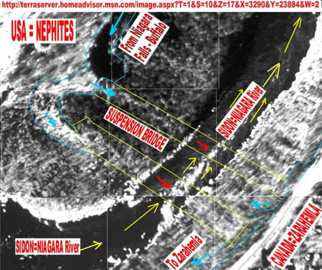
DETAILS OF THE BORDER OF ZARAHEMLA WITH NEFITES LANDS AND FINDING THE HUGE "SUSPENDED BRIDGES" LINKING SUCH KINGDOMS
A "STRANGE VIEWPOINT" on the GEOGRAPHY of the Book of Mormon based on FIRST HAND information provided by the very FIRST LEADERS and PROPHETS.
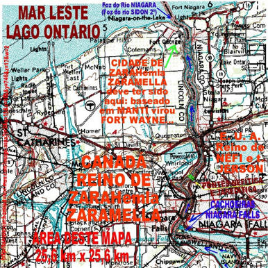
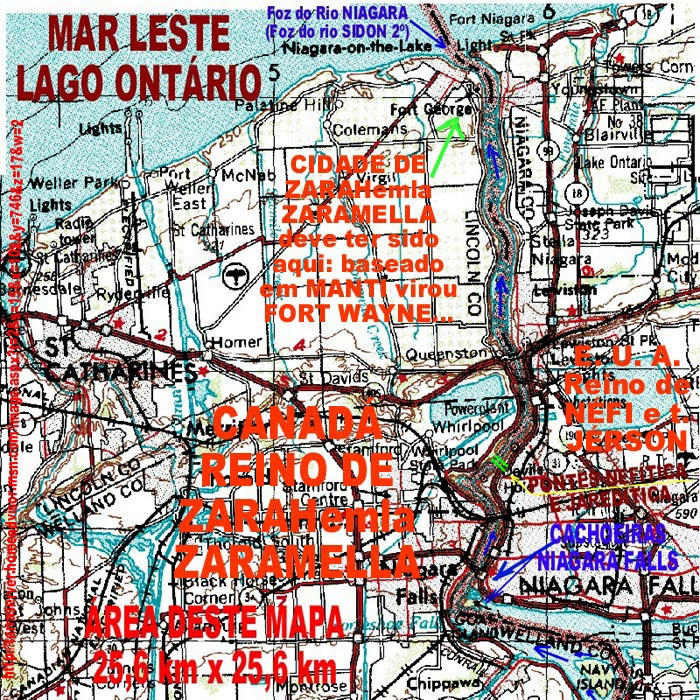
From that and from Book of Mormon itself we conclude that CUMORAH is "ON the EAST SEA", thus quite on shore line of ONTARIO LAKE, which is the EAST SEA, as it is EAST side of NIAGARA ISTHMUS (the narrow strip of land separating EAST SEA=ONTARIO LAKE to the WEST SEA=ERIE LAKE and ERIE LAKE is WEST sided in relation to the ONTARIO LAKE=EAST SEA and of ISTHMUS of NIAGARA...). The information that CUMORAH HILL was "ON" EAST SEA, thus ON Ontario Lake, was provided by Prophet Joseph Smith in the event he was camped at the margin of Illinois River and disclosed about the skeleton of the White Lamanite ZELPH as being known from Cumorah Hill, next to EAST SEA, to Rock Mountains... History of Church...
Knowing that the NEPHITIC KINGDOM was from the CUMORAH HILL, and beyound, going to N.Y. State and N.Y. town itself (the "gate" for LIBERTY LAND, with the Liberty Statue herself providing the WELCOME at the HARBOR...), and looking at the TOPOGRAPHIC information provided in the Book of Mormon, with eyes of TOPOGRAPHS, we can quite easily conclude what will be presented BELOW. The position of ZARAHemla (a hybrid JEW-ARAB name, of Mulekites+Arab crew and ARAB WOMEN... WOW!) fort town and the position of main road going to CUMORAH and how it was linked to the town of ZARAHemla, by INDIAN trails. Thus we are to start with the INDIAN TRAILS and ZarahEMLA. That is a quite nice TOPOGRAPHIC work, as it provides an easy way to find and locate towns and GEOGRAPHY OF Book of Mormon, even to find the missing towns, as the ones that SUNK into the SEA (GREAT LAKES... as some INDIANS TRAIL have their pathway going INTO the SEA...).
HUM!!! You can see, in the proper locked=censorshiped (Medieval inquisition?) site about 1921 Book of Mormon GEOGRAPHY ...., how retrieving the INDIAN TRAILS provided the location of MANTI town (nowadays DETROIT town, USA) and of the quite nearby hill where we have the RIPLIANCUM splendid and vast VIEW of the WEST SEA and some more waters, as SIDON RIVER passing by MANTI TOWN and HURON LAKE (North Sea) and more... and the position where the Lamanites, that were killed trying to cross SIDON RIVER and reaching the other margin (and going NORTH Sea and North Lands). There they SANK and were "buried" into the bottom of WEST SEA (lake ERIE, which is SIDON RIVER "LENTHIC").
http://www.mediafire.com/imgbnc.php/d1af7cde164187e5ad18528e4927abbd966a00094293091ca2a60857d1a9ba846g.jpg
very ENLARGED image
not so ENLARGED image.
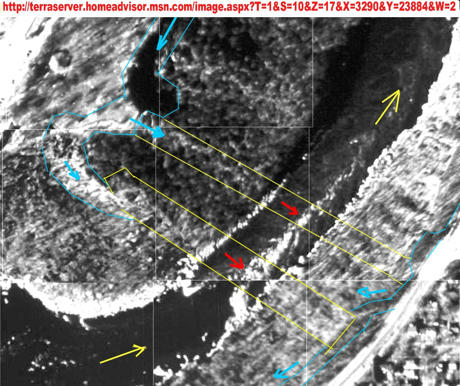
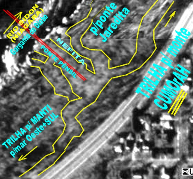
You can see the SIDON RIVER (NIAGARA RIVER) in its final pathway, from down part to upper part of your video screen, discharging into the EAST SEA, EASTERN SEA, which is LAKE ONTARIO. On very top is the start of the ERIE=NIAGARA LAKE, and on LEFT of it we have a MODERN CANADIAN TOWN (militar fort) that in past was a MULEKITE town, the ZARAHemla town and fort, that was protected by the high walls and fast water velocity of Niagara River (thus the existence of modern fort, in both sides).
River SIDON=NIAGARA was crossing, since town BUFFALO (AMNIHU) a NARROW "WILDERNESS" strip of water and vegetation, a WATER FENCE separating NEPHITES and ZARAHEMLITES. In the right side, USA side, it was sited the Indian trail going (upward) toward CUMORAH HILL. And if downward it was a way to go, through SUSPENDED BRIDGE, to ZARAHemla. Or through boats in Erie Lake, facing the NAVY of the Zarahemla Forces (Army).
http://www.mediafire.com/imgbnc.php/5a5e22a6a7012b97644dbdb0a254a47bd5e05f4ddc7c57eafc32fda4376931fa6g.jpg
very enlarged image
quite reduced size image.
You can see, encircled by a thick yellow line, more or less is the limits of the OLD ZARAHEMLA town, now built with a modern Canadian town (fort). You can see also the Indian trails, along both margins of the Niagara River (Sidon River "LOTHIC condition") in the way they were going to ZARAHEMLA and to CUMORAH HILL and others places. It is evident that modern construction and agricultural uses of the land destroy the evidences of such old Indian trails.
http://www.mediafire.com/imgbnc.php/099f382f5e06cb9817040abf3e10bc69faa0259398649d5a25478ca39fe5d47a6g.jpg
very enlarged image
smaller sized image
You can see we moved upstream, to the mouth of ERIE LAKE into the NIAGARA RIVER while keeping the discharge of NIAGARA RIVER into the ONTARIO LAKE. Thus now this map is showing the whole ISTHMUS of NIAGARA. The paradise for the USA and CANADIAN turism industry with NIAGARA FALLS... Even my wife and I went there to enjoy such so very beautiful place.
Please, pay attention to your LEFT, to a CHANNEL that is the WELLAND CHANNEL, build in the SHORTEST DISTANCE between WEST SEA and EAST SEA (ERIE LAKE and ONTARIO LAKE) through the NARROWEST of the NECK of the LAND separating them.... Thus such CHANNEL is exactly following the PATHWAY described in the Book of Mormon, in great detail, as the distance a Nephite would follow during one and a half day to walk, as being the MINIMUM to go from EAST SEA (Lake Ontario) to the WEST SEA (Lake Erie)...
BE SMART as scientist eating and drinking not too much bitter salt: LDS diet is unhealthy when try you to eat and drink Meso-America...
Such Welland channel was also built to transport a huge flow of FRESH WATER to supply it for hydropower generation at the bi-national hydroelectric (USA-CANADIAN) at the shoreline of ONTARIO LAKE. Why was it built at the shortest distance possible? Based on Book of Mormon? Not in Mexico or Guatemala? I am engineer, but if a ROAD can be made in a shorter distance, it will cost less, as a normal rule of good engineering... Thus you try to have the least distance pathway between two points, not making unnecessary curves and length, as going to Guatemala and returning.
Look at what happens just after (downstream) of NIAGARA FALLS.... HUM? DEVIL HOLES? Guess right? WRONG.
Two huge SUSPENDED BRIDGES, as those built by the BRIDGES in PERU, with NEPHITES technology... HUM! NEPHITES technology? WOW? But Nephites had disappeared... Are you sure? I am nephite descandent: Guarany = "Humble RED dark Skin".
Look at the MAP, just some little downstream the falls of Niagara Falls (going upward in your screen), and you will see two parallel GREEN LINES crossing the NIAGARA RIVER (just at the "left" of the word JERSON, which is in the right side of Niagara River...). Such two lines, in vivid briliant green, are two SUSPENDED BRIDGES. (Maybe another third line was built but it was of very little use...
Going upward, you are following Niagara River downstream, reaching the discharge into ONTARIO LAKE, which is on very top of the map. At the left side of discharge is ZARAHEMLA. The place for the "confort, relief" of captain ZARAH. After sufferings in bringuing such crew and passengers to such place of relief of pains and sufferings.
In modernity ZARAHEMLA is "FORT GEORGE", militar town of CANADA, which was totally made in WOOD (also as many USA fort towns). Thus Book of Mormon is correct, that STONE was not required to make towns or even FORT TOWNS in cold places and where wood is abundant. So false WISES teach wrong about HOUSING by Nephites. MANTI should had been made totally in wood and Earth reinforcements (hills + ditches).
http://www.mediafire.com/imgbnc.php/fbde46c27499fc08063df924cf591bd27275a5ab66d28fc51d43131988a1e7196g.jpg
very enlarged image

small sized image
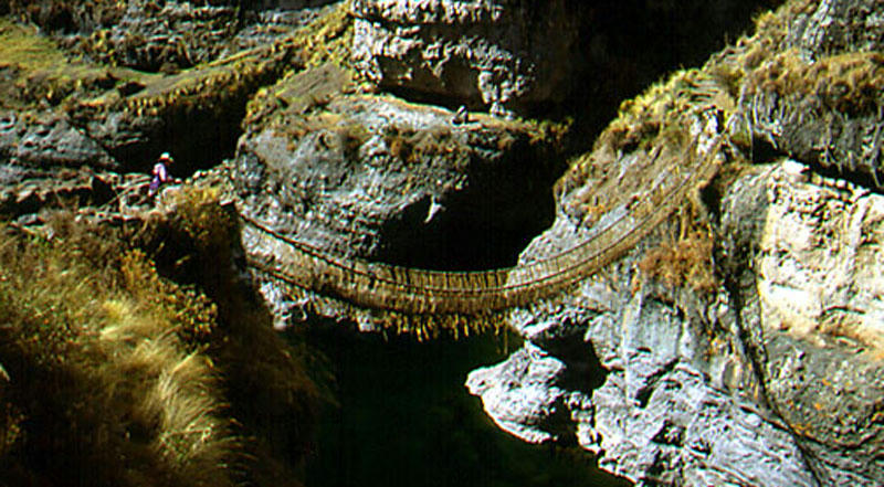
You can see an INCA SUSPENDED BRIDGE, in Peru, quite like GOLDEN GATE BRIDGE of San Francisco, USA. But made with INDIAN (NEPHITIC) TECHNOLOGY. Maybe the technology came originally from the JAREDITES and it was improved and enlarged by the Nephites.
http://www.mediafire.com/imgbnc.php/a2c12b658350119bfc2236a4bad2fb3a88393a01ef86fd278a2f1cce1977f9876g.jpg
very enlarged map
smaller sized image
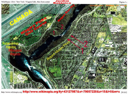
http://www.wikimapia.org/#y=43127987&x=-79057220&z=15&I=0&m=s
AT THIS TIJME THE VEGETATION WAS COVERING THE SOIL, THUS COVERING INDIAN TRIALS AND ANY EVIDENCE OF THE SUSPENDED BRIDGE EVIDENCES OF HAVING EXISTENCE IN PAST.
http://www.wikimapia.org/#lat=43.127987&lon=-79.05722&z=13&l=9&m=s
A very broad view, as if from a very high altitude flight.
http://www.wikimapia.org/#lat=43.127987 ... 17&l=9&m=s
A very close up view, showing quite like Indian pathway (dense walked) toward NOTHING: the suspended bridge (that is missing). At the time of picture the vegetation was covering the soil (not the case of previous pictures, showing the bare soil, rocky: limestones).
Between the positions "1 to 1", crossing the River Niagara, and "2 to 2", crossing the River Niagara, are the two SUSPENDED BRIDGES located on the map. See next.
[url]
http://www.mediafire.com/imgbnc.php/117 ... 6c126g.jpg[/url]
very enlarged picture.
small sized picture.
You can see the NIAGARA RIVER (SIDON RIVER) flowing downstream Niagara Falls toward ZARAHEMLA, thus toward Devils Hole throat, the place for the two (3 ?) Suspende Bridge. For some time I worked in a Construction and planning and design of bridges (including suspended bridges) and tunnels and huge structures: 40 years ago... Maybe the right side suspended bridge could had been Jareditic design... and it was rebuilt by Nephites. With increasing traffic they built a larger one, at the left.
http://www.mediafire.com/imgbnc.php/4a57897f5e4a66e541a351b058314e5997674762e225f9f0c8d21f89235bd0ab6g.jpg
Very enlarged picture - design
 g
g
small sized picture - design.
You can see the schematic design of the "shoulder" of the suspended bridge on its support at the left side, when bridge touchs the ground. It appears there were some type of parking place for people waiting their time of crossing and for some type of CUSTOMS/iMMIGRATION. Red lines going upward to the left probably were toward roads (Indian trail) along the shoreline of ERIE Lake, as to board Sail Ship Haggoth's type to travel to Manti... And red lines going to the right probably were toward Zarahemla, bordering very close the Niagara (Sidon) River. The intermediate pair or red lines would go to some intermediate places. At the time of this picture there was no vegetation.
http://www.mediafire.com/imgbnc.php/d95e64b6e1aabfc226986ff85be4b2d690b906f32baea0a465b8fd6409b92f996g.jpg
very enlarged picture, showing nice ground.
quite small sized picture
You can see that probably we may had a THIRD SUSPENDED BRIDGE in parallel to the other two main bridges. It appears it was "downstream" sited (upper of video).
http://www.mediafire.com/imgbnc.php/e3d5704e53dc20d62da617cbb8f5b936c1c96383780cd0673c7e7cdd070834525g.jpg
Average sized map, of good size. Click on previous URL to see IMAGE.
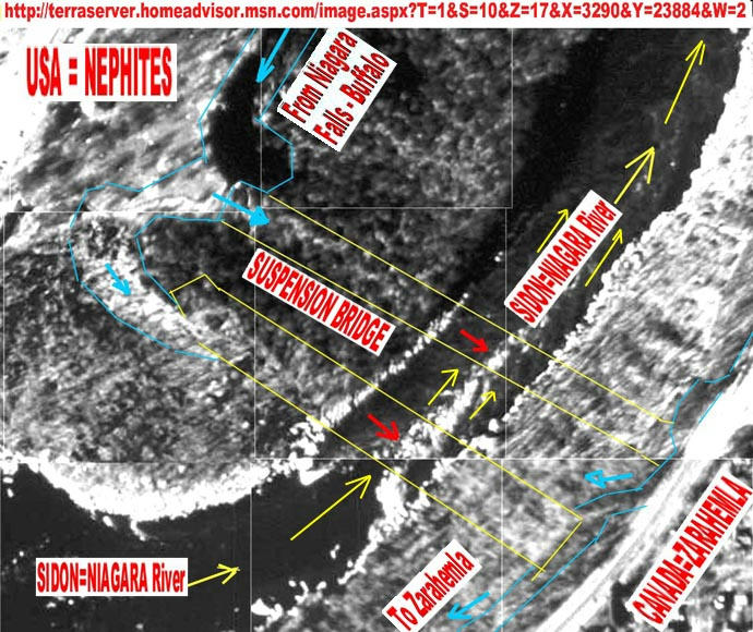
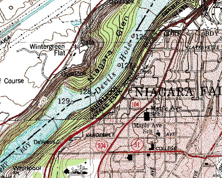
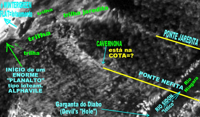
As a civil hydraulic, sanitary and environmental engineer, I appreciate to use good topographic/aerophotogrametric maps, as this one provided by U.S.G.S. of USA and in fact it is very good to examine precise technical information, as from Book of Mormon, with precise and reliable maps, as from USGS. You can see the place for 2 or 3 Suspended Bridges, in parallel position, crossing the Niagara River (Sidon river or THE GREAT CID RIVER... eL Cid), are for the position or place "128" at the deepest of the River Niagara, receiving the title "Devils Hole". For sure any person falling from the Suspended Bridge and falling on water, was sinked into Devils Hole... Sure DEATH.
http://img3.mediafire.com/233db52e11edb8ff6a1f1bc8914293580d01f5fcd0322b352684430c7ea6b4be5g.jpg
Click on previous URL to see very enlarged IMAGE. Other view of the LEFT SHOULDER of the Suspended Bridges passing over the Devils Hole of Niagara River.
http://img14.mediafire.com/d4f770612527eaab7a089cbdd876194bf593c651d4d49b52a944535df3cc4ca85g.jpg
Click on previous URL to see very enlarged IMAGE. This is the RIGHT SHOULDER of the Suspended Bridges passing over the Devils Hole of the Niagara River (as seen on top of your video screen). Arriving in quite like the modern bordering avenue, you have the old Indian trails had a pathway goind left to MANTI town by bordering the EAST side (margin) of the WEST SEA (Lake ERIE) and then turning right at the far end and reaching Manti (nowadays Detroit). The other Indian trail pathway, in the opposite direction, departing from the suspended bridges, was going to CUMORAH HILL.
http://img30.mediafire.com/dbb07cb4bff7d32daef433cdcbdc44dbd7e9f0c39188322b0315f1edaba6a3855g.jpg
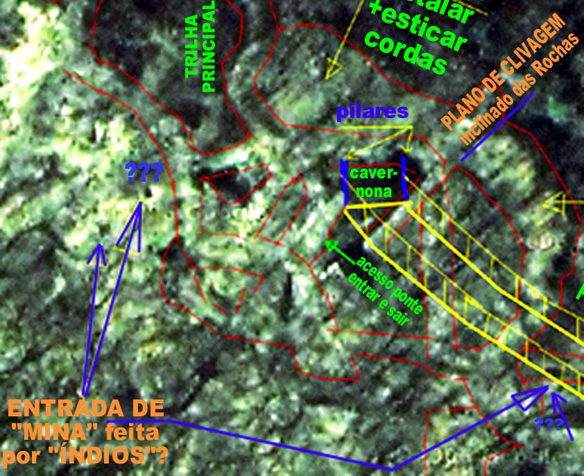
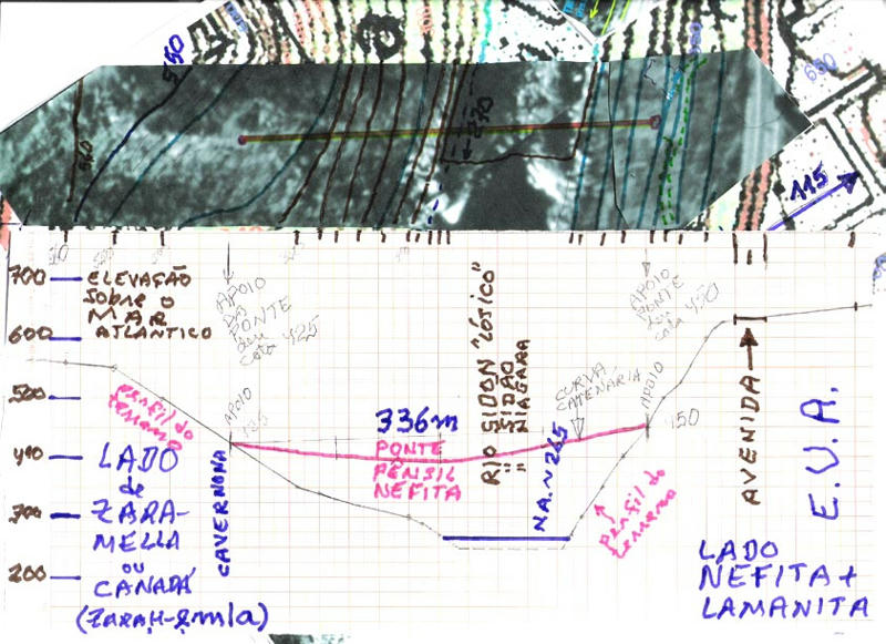
Click on previous URL to see very enlarged IMAGE. The main suspended bridge is presented in PLAN VIEW (design in upper part) and in a VERTICAL CROSS-SECTION (in the lower part). You can see it was quite long, being of some 336 m length (some 1,000 ft). Even a respectiful span for modern suspended bridge without counter-weight provision, as in this case (no space...). Probably they used the caves for such purpose of anchorage... (see the pictures of something like caves...). Quite like marvelous engineering undertaking. Some 130m above the turbulent waters of Sidon River flowing quite like toward the h*** in great and deadly noises...
Best personal regards, sincerely yours, ELYSAB
A "STRANGE VIEWPOINT" on the GEOGRAPHY of the Book of Mormon based on FIRST HAND information provided by the very FIRST LEADERS and PROPHETS.
From that and from Book of Mormon itself we conclude that CUMORAH is "ON the EAST SEA", thus quite on shore line of ONTARIO LAKE, which is the EAST SEA, as it is EAST side of NIAGARA ISTHMUS (the narrow strip of land separating EAST SEA=ONTARIO LAKE to the WEST SEA=ERIE LAKE and ERIE LAKE is WEST sided in relation to the ONTARIO LAKE=EAST SEA and of ISTHMUS of NIAGARA...). The information that CUMORAH HILL was "ON" EAST SEA, thus ON Ontario Lake, was provided by Prophet Joseph Smith in the event he was camped at the margin of Illinois River and disclosed about the skeleton of the White Lamanite ZELPH as being known from Cumorah Hill, next to EAST SEA, to Rock Mountains... History of Church...
Knowing that the NEPHITIC KINGDOM was from the CUMORAH HILL, and beyound, going to N.Y. State and N.Y. town itself (the "gate" for LIBERTY LAND, with the Liberty Statue herself providing the WELCOME at the HARBOR...), and looking at the TOPOGRAPHIC information provided in the Book of Mormon, with eyes of TOPOGRAPHS, we can quite easily conclude what will be presented BELOW. The position of ZARAHemla (a hybrid JEW-ARAB name, of Mulekites+Arab crew and ARAB WOMEN... WOW!) fort town and the position of main road going to CUMORAH and how it was linked to the town of ZARAHemla, by INDIAN trails. Thus we are to start with the INDIAN TRAILS and ZarahEMLA. That is a quite nice TOPOGRAPHIC work, as it provides an easy way to find and locate towns and GEOGRAPHY OF Book of Mormon, even to find the missing towns, as the ones that SUNK into the SEA (GREAT LAKES... as some INDIANS TRAIL have their pathway going INTO the SEA...).
HUM!!! You can see, in the proper locked=censorshiped (Medieval inquisition?) site about 1921 Book of Mormon GEOGRAPHY ...., how retrieving the INDIAN TRAILS provided the location of MANTI town (nowadays DETROIT town, USA) and of the quite nearby hill where we have the RIPLIANCUM splendid and vast VIEW of the WEST SEA and some more waters, as SIDON RIVER passing by MANTI TOWN and HURON LAKE (North Sea) and more... and the position where the Lamanites, that were killed trying to cross SIDON RIVER and reaching the other margin (and going NORTH Sea and North Lands). There they SANK and were "buried" into the bottom of WEST SEA (lake ERIE, which is SIDON RIVER "LENTHIC").
http://www.mediafire.com/imgbnc.php/d1af7cde164187e5ad18528e4927abbd966a00094293091ca2a60857d1a9ba846g.jpg
very ENLARGED image
not so ENLARGED image.
You can see the SIDON RIVER (NIAGARA RIVER) in its final pathway, from down part to upper part of your video screen, discharging into the EAST SEA, EASTERN SEA, which is LAKE ONTARIO. On very top is the start of the ERIE=NIAGARA LAKE, and on LEFT of it we have a MODERN CANADIAN TOWN (militar fort) that in past was a MULEKITE town, the ZARAHemla town and fort, that was protected by the high walls and fast water velocity of Niagara River (thus the existence of modern fort, in both sides).
River SIDON=NIAGARA was crossing, since town BUFFALO (AMNIHU) a NARROW "WILDERNESS" strip of water and vegetation, a WATER FENCE separating NEPHITES and ZARAHEMLITES. In the right side, USA side, it was sited the Indian trail going (upward) toward CUMORAH HILL. And if downward it was a way to go, through SUSPENDED BRIDGE, to ZARAHemla. Or through boats in Erie Lake, facing the NAVY of the Zarahemla Forces (Army).
http://www.mediafire.com/imgbnc.php/5a5e22a6a7012b97644dbdb0a254a47bd5e05f4ddc7c57eafc32fda4376931fa6g.jpg
very enlarged image
quite reduced size image.
You can see, encircled by a thick yellow line, more or less is the limits of the OLD ZARAHEMLA town, now built with a modern Canadian town (fort). You can see also the Indian trails, along both margins of the Niagara River (Sidon River "LOTHIC condition") in the way they were going to ZARAHEMLA and to CUMORAH HILL and others places. It is evident that modern construction and agricultural uses of the land destroy the evidences of such old Indian trails.
http://www.mediafire.com/imgbnc.php/099f382f5e06cb9817040abf3e10bc69faa0259398649d5a25478ca39fe5d47a6g.jpg
very enlarged image
smaller sized image
You can see we moved upstream, to the mouth of ERIE LAKE into the NIAGARA RIVER while keeping the discharge of NIAGARA RIVER into the ONTARIO LAKE. Thus now this map is showing the whole ISTHMUS of NIAGARA. The paradise for the USA and CANADIAN turism industry with NIAGARA FALLS... Even my wife and I went there to enjoy such so very beautiful place.
Please, pay attention to your LEFT, to a CHANNEL that is the WELLAND CHANNEL, build in the SHORTEST DISTANCE between WEST SEA and EAST SEA (ERIE LAKE and ONTARIO LAKE) through the NARROWEST of the NECK of the LAND separating them.... Thus such CHANNEL is exactly following the PATHWAY described in the Book of Mormon, in great detail, as the distance a Nephite would follow during one and a half day to walk, as being the MINIMUM to go from EAST SEA (Lake Ontario) to the WEST SEA (Lake Erie)...
BE SMART as scientist eating and drinking not too much bitter salt: LDS diet is unhealthy when try you to eat and drink Meso-America...
Such Welland channel was also built to transport a huge flow of FRESH WATER to supply it for hydropower generation at the bi-national hydroelectric (USA-CANADIAN) at the shoreline of ONTARIO LAKE. Why was it built at the shortest distance possible? Based on Book of Mormon? Not in Mexico or Guatemala? I am engineer, but if a ROAD can be made in a shorter distance, it will cost less, as a normal rule of good engineering... Thus you try to have the least distance pathway between two points, not making unnecessary curves and length, as going to Guatemala and returning.
Look at what happens just after (downstream) of NIAGARA FALLS.... HUM? DEVIL HOLES? Guess right? WRONG.
Two huge SUSPENDED BRIDGES, as those built by the BRIDGES in PERU, with NEPHITES technology... HUM! NEPHITES technology? WOW? But Nephites had disappeared... Are you sure? I am nephite descandent: Guarany = "Humble RED dark Skin".
Look at the MAP, just some little downstream the falls of Niagara Falls (going upward in your screen), and you will see two parallel GREEN LINES crossing the NIAGARA RIVER (just at the "left" of the word JERSON, which is in the right side of Niagara River...). Such two lines, in vivid briliant green, are two SUSPENDED BRIDGES. (Maybe another third line was built but it was of very little use...
Going upward, you are following Niagara River downstream, reaching the discharge into ONTARIO LAKE, which is on very top of the map. At the left side of discharge is ZARAHEMLA. The place for the "confort, relief" of captain ZARAH. After sufferings in bringuing such crew and passengers to such place of relief of pains and sufferings.
In modernity ZARAHEMLA is "FORT GEORGE", militar town of CANADA, which was totally made in WOOD (also as many USA fort towns). Thus Book of Mormon is correct, that STONE was not required to make towns or even FORT TOWNS in cold places and where wood is abundant. So false WISES teach wrong about HOUSING by Nephites. MANTI should had been made totally in wood and Earth reinforcements (hills + ditches).
http://www.mediafire.com/imgbnc.php/fbde46c27499fc08063df924cf591bd27275a5ab66d28fc51d43131988a1e7196g.jpg
very enlarged image
small sized image
You can see an INCA SUSPENDED BRIDGE, in Peru, quite like GOLDEN GATE BRIDGE of San Francisco, USA. But made with INDIAN (NEPHITIC) TECHNOLOGY. Maybe the technology came originally from the JAREDITES and it was improved and enlarged by the Nephites.
http://www.mediafire.com/imgbnc.php/a2c12b658350119bfc2236a4bad2fb3a88393a01ef86fd278a2f1cce1977f9876g.jpg
very enlarged map
smaller sized image
http://www.wikimapia.org/#y=43127987&x=-79057220&z=15&I=0&m=s
AT THIS TIJME THE VEGETATION WAS COVERING THE SOIL, THUS COVERING INDIAN TRIALS AND ANY EVIDENCE OF THE SUSPENDED BRIDGE EVIDENCES OF HAVING EXISTENCE IN PAST.
http://www.wikimapia.org/#lat=43.127987&lon=-79.05722&z=13&l=9&m=s
A very broad view, as if from a very high altitude flight.
http://www.wikimapia.org/#lat=43.127987 ... 17&l=9&m=s
A very close up view, showing quite like Indian pathway (dense walked) toward NOTHING: the suspended bridge (that is missing). At the time of picture the vegetation was covering the soil (not the case of previous pictures, showing the bare soil, rocky: limestones).
Between the positions "1 to 1", crossing the River Niagara, and "2 to 2", crossing the River Niagara, are the two SUSPENDED BRIDGES located on the map. See next.
[url]
http://www.mediafire.com/imgbnc.php/117 ... 6c126g.jpg[/url]
very enlarged picture.
small sized picture.
You can see the NIAGARA RIVER (SIDON RIVER) flowing downstream Niagara Falls toward ZARAHEMLA, thus toward Devils Hole throat, the place for the two (3 ?) Suspende Bridge. For some time I worked in a Construction and planning and design of bridges (including suspended bridges) and tunnels and huge structures: 40 years ago... Maybe the right side suspended bridge could had been Jareditic design... and it was rebuilt by Nephites. With increasing traffic they built a larger one, at the left.
http://www.mediafire.com/imgbnc.php/4a57897f5e4a66e541a351b058314e5997674762e225f9f0c8d21f89235bd0ab6g.jpg
Very enlarged picture - design
small sized picture - design.
You can see the schematic design of the "shoulder" of the suspended bridge on its support at the left side, when bridge touchs the ground. It appears there were some type of parking place for people waiting their time of crossing and for some type of CUSTOMS/iMMIGRATION. Red lines going upward to the left probably were toward roads (Indian trail) along the shoreline of ERIE Lake, as to board Sail Ship Haggoth's type to travel to Manti... And red lines going to the right probably were toward Zarahemla, bordering very close the Niagara (Sidon) River. The intermediate pair or red lines would go to some intermediate places. At the time of this picture there was no vegetation.
http://www.mediafire.com/imgbnc.php/d95e64b6e1aabfc226986ff85be4b2d690b906f32baea0a465b8fd6409b92f996g.jpg
very enlarged picture, showing nice ground.
quite small sized picture
You can see that probably we may had a THIRD SUSPENDED BRIDGE in parallel to the other two main bridges. It appears it was "downstream" sited (upper of video).
http://www.mediafire.com/imgbnc.php/e3d5704e53dc20d62da617cbb8f5b936c1c96383780cd0673c7e7cdd070834525g.jpg
Average sized map, of good size. Click on previous URL to see IMAGE.
As a civil hydraulic, sanitary and environmental engineer, I appreciate to use good topographic/aerophotogrametric maps, as this one provided by U.S.G.S. of USA and in fact it is very good to examine precise technical information, as from Book of Mormon, with precise and reliable maps, as from USGS. You can see the place for 2 or 3 Suspended Bridges, in parallel position, crossing the Niagara River (Sidon river or THE GREAT CID RIVER... eL Cid), are for the position or place "128" at the deepest of the River Niagara, receiving the title "Devils Hole". For sure any person falling from the Suspended Bridge and falling on water, was sinked into Devils Hole... Sure DEATH.
http://img3.mediafire.com/233db52e11edb8ff6a1f1bc8914293580d01f5fcd0322b352684430c7ea6b4be5g.jpg
Click on previous URL to see very enlarged IMAGE. Other view of the LEFT SHOULDER of the Suspended Bridges passing over the Devils Hole of Niagara River.
http://img14.mediafire.com/d4f770612527eaab7a089cbdd876194bf593c651d4d49b52a944535df3cc4ca85g.jpg
Click on previous URL to see very enlarged IMAGE. This is the RIGHT SHOULDER of the Suspended Bridges passing over the Devils Hole of the Niagara River (as seen on top of your video screen). Arriving in quite like the modern bordering avenue, you have the old Indian trails had a pathway goind left to MANTI town by bordering the EAST side (margin) of the WEST SEA (Lake ERIE) and then turning right at the far end and reaching Manti (nowadays Detroit). The other Indian trail pathway, in the opposite direction, departing from the suspended bridges, was going to CUMORAH HILL.
http://img30.mediafire.com/dbb07cb4bff7d32daef433cdcbdc44dbd7e9f0c39188322b0315f1edaba6a3855g.jpg
Click on previous URL to see very enlarged IMAGE. The main suspended bridge is presented in PLAN VIEW (design in upper part) and in a VERTICAL CROSS-SECTION (in the lower part). You can see it was quite long, being of some 336 m length (some 1,000 ft). Even a respectiful span for modern suspended bridge without counter-weight provision, as in this case (no space...). Probably they used the caves for such purpose of anchorage... (see the pictures of something like caves...). Quite like marvelous engineering undertaking. Some 130m above the turbulent waters of Sidon River flowing quite like toward the h*** in great and deadly noises...
Best personal regards, sincerely yours, ELYSAB