Kingdom ZARAHEMLA since land of MANTI. Separated by SIDON

The upper-crust forum for scholarly, polite, and respectful discussions only. Heavily moderated. Rated G.
_ELYSAB
_Emeritus
Posts: 189
Joined: Thu Aug 18, 2011 10:54 pm

Re: Kingdom ZARAHEMLA since land of MANTI. Separated by SIDON

Post by _ELYSAB »

Image

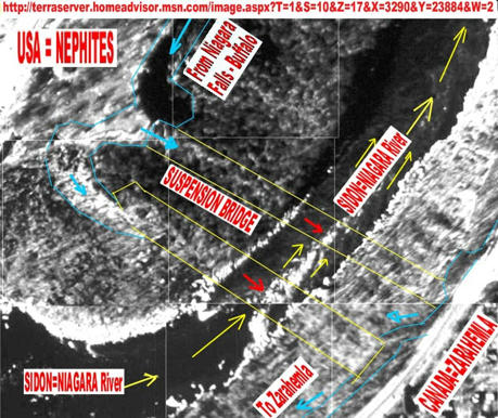
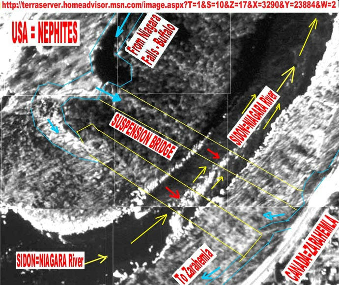
You can see two suspended bridges crossing the Sidon River = Niagara River donstream (after) the Niagara Falls, quite over the Devils Hole gorge (very narrow width place). The bridges are "suggested" by the yellow lines crossing the River and you can see on the steep sloped Rocky limed (calcium carbone) margin, the "yellow" effect of bare rock (none vegetation grown on it), result of people walking on it to pull the ropes and also the attrition of ropes against the limed rock margin, making it become a "bare rock", quite like "marble surface", white one. We can see we have 3 pathways of such "white pathways", in parallel and the third one, more downstream, suggest the bridge had little use. The most used was the first suspended bridge, from left to your right. The second one was probably of middle age, and the right one, the youngest.

http://img2.mediafire.com/1170d96b867d87d1a5d375bb5589b477c4a088a9a568e22dc5e251e866066c126g.jpg
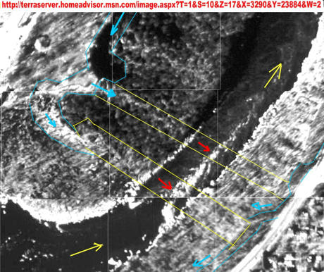
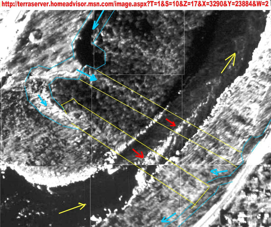
The same picture, very enlarged.

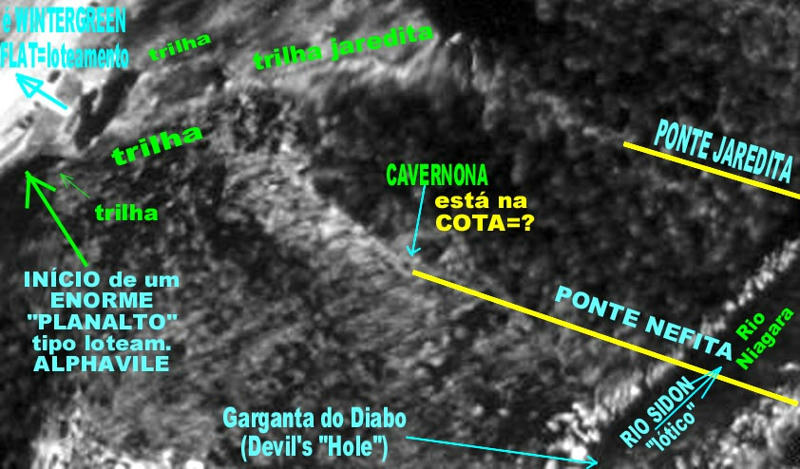
End of the Suspended Bridge at its Left end (as we see), in the Canadian margin (Zarahemla's kingdom side), showing the pathway to bring people to cross or that crossed the suspended bridge and the cables (ropes) responsible for the suspension of the bridge over abyss, and going into caves for anchorage and for people getting into and out of the bridge.

Image

The same viu, very enlarged, click on next URL:
http://img5.mediafire.com/4a57897f5e4a66e541a351b058314e5997674762e225f9f0c8d21f89235bd0ab6g.jpg


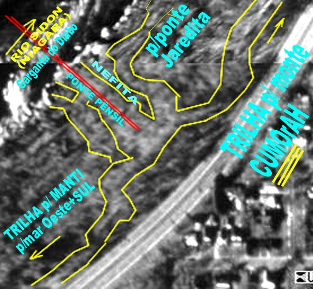
The design of the right shoulder = end = coupling = support of the suspended bridge on the margin of Niagara=Sidon River in the Nephite Kingdom (USA kingdom), that is your Right view of Niagara River. It was to be quite a big and steep stairway, up to nearby the nowadays avenue that there is there.
Image

You can see the details of RIGHT SIDE of the suspended bridge, in this enlarged view of it:
http://img14.mediafire.com/d95e64b6e1aabfc226986ff85be4b2d690b906f32baea0a465b8fd6409b92f996g.jpg


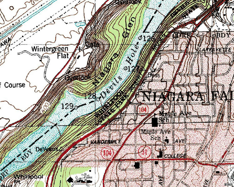
For you have a good location on the maps of USA and CANADA and of BUFFALO, reason that the Suspended Bridges crossed over the poiint "128" of the detailed palimetric and altimetric map (just below) provided by the U. S. G. S. of U.S.Gov. The bridges were perpendicular to the Perimetral Avenue (in RED COLOR), which limits the urban area in USA side (your right side). The bridges crossed over the "Devil Hole": a very deep and turbulent hole. For sure any person falling from the Suspended Bridge and falling on water, was sinked into Devils Hole... None hope of survival.

http://img3.mediafire.com/233db52e11edb8ff6a1f1bc8914293580d01f5fcd0322b352684430c7ea6b4be5g.jpg
CLOSE UP view of the two most important suspended bridges at their fastening in the left margin of the Niagara River (Sidon River). First we see the most important, in foreground, the bigger one.

Image

CLICK TO SEE such shoulders of Suspended bridge in Zarahemla side.


CLOSE UP view of the tow most important suspended bridges at their fastening and tensioning (into caves) in the right margin of the Niagara River (Sidon River). In your left side is the most important bridge, the bigger one.

http://img30.mediafire.com/d4f770612527eaab7a089cbdd876194bf593c651d4d49b52a944535df3cc4ca85g.jpg
CLICK TO SEE IT IN AN ENLARGED SIZE.

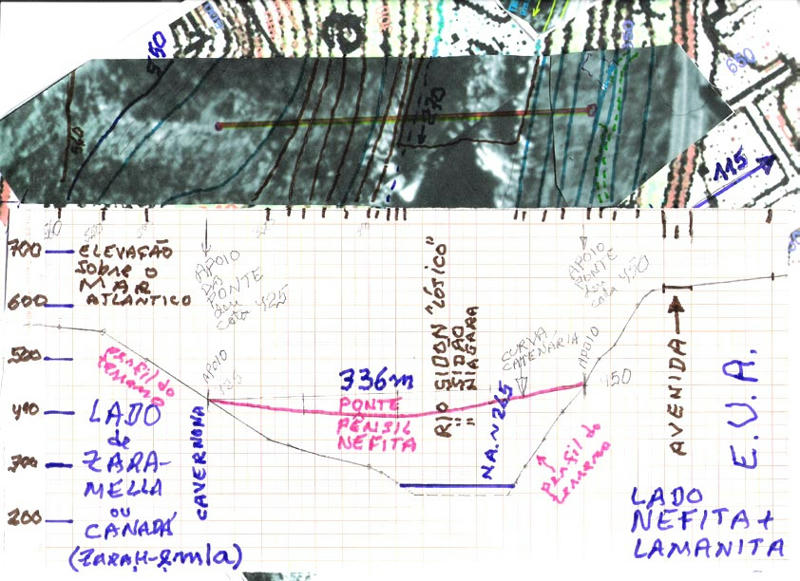
This is the cross-section of the Niagara River, along the pathway of the Suspended Bridges. On top is the superposition of the bridges pathway with the land pathway (provided by the USGS maps). As result we got, in the lower part, the Cross-section profile, showing the pathway of the Suspended Bridge in relation to the Margins of the Land and of the Water Level, when based on same altimetry and planimetry referential. The suspended bridge, the bigger one, was to have 336 m long and over crossing the River Niagara have the maximum height of [b]165 FT = 50.3m (it is not in "M", map is from USGS, 336 yd and not 336 m) above the water level of Niagara River (!!!) [/b] having an elevation of 265 ft=80.8m (not "265 M") above sea level. Thus the suspended bridge is not so "terrible" because USA didn't become "metric". Were the NEPHITES already "metric" and living in USA?

http://img14.mediafire.com/dbb07cb4bff7d32daef433cdcbdc44dbd7e9f0c39188322b0315f1edaba6a3855g.jpg

Click on above URL and see enlarged.
_ELYSAB
_Emeritus
Posts: 189
Joined: Thu Aug 18, 2011 10:54 pm

Re: Kingdom ZARAHEMLA since land of MANTI. Separated by SIDON

Post by _ELYSAB »

Picture, as if from satelite, in WIKIMAPIA site, is from point 128 of the USGS map,
Image

And you can see so many "holes" on the quite steep and rocky margin. But some of them are cleary man made caves. Including the most probably hole is the one, in such better viewing, that shows a HUGE "MOUTH" (somewhat 20-25m width x 15m height in ARCH), almost at the top of the screen, on half the way to the right. It could fit even accomodate the very gigantic Suspended Bridge, the "big first one", going downstream, shown in previous drawings and pictures.
http://wikimapia.org/#lat=43.1277251&lon=-79.0589932&z=18&l=0&m=b

Next you can see such ARCH of 20m width x 15m heigh so visible, that you can see it as part of the first Indian Pathway going down from the Indian Trail diversion (on top) to 3 destinations, each one toward th Niagara=Sidon River, each one having a Suspension Bridge crossing, over the "Devils Hole Rapids". Here we can see nicelly only two of such trials feeding two suspension bridges. Other was too new

http://wikimapia.org/#lat=43.1277251&lon=-79.0589932&z=17&l=0&m=b

This is a more general view of the position of the 3 Suspended bridges half way between Niagara Wirhlpool and Niagara Glen.

http://wikimapia.org/#lat=43.1277251&lon=-79.0589932&z=15&l=0&m=b


Other view of the two Indian trails feeding the trails going to the Indian Suspended Bridges crossing the Niagara = Sidon River. Noticed that the Indian Trail coming from Zarahemla was used as path to built the FENCE along it, up to the point where it was divert to feed the two indian trails feeding the Suspended Bridges. Notice the huge cave in the sistem to support and feed the main and first suspended bridge crossing the Niagara = Sidon River.

http://wikimapia.org/#lat=43.1287587&lon=-79.0579498&z=18&l=0&m=b

And then the detail, very enlarged, of such system feeding indians into the huge cave, and returning transported indians from such Indians through suspended bridges, into the stairway and ramps, along the slope of the Niagara = Sidon river, up to the place where the flow of indians and merchandise from other upward trail were added, in the converging zone, on top, and diverted toward ZARAHEMLA, or toward a SEA HARBOR to the NORTH SEA, as to HAGOTH's harbor, quite nearby, to transport in SAIL SHIP. This was a short cut, of "little ants".

http://wikimapia.org/#lat=43.1287587&lon=-79.0579498&z=18&l=0&m=b
_ELYSAB
_Emeritus
Posts: 189
Joined: Thu Aug 18, 2011 10:54 pm

Re: Kingdom ZARAHEMLA since land of MANTI. Separated by SIDON

Post by _ELYSAB »

INDIAN TRAILS in NEPHI's side and in ZARAHEMLA's side of SIDON (Niagara) river in the region of NIAGARA FALLS - USA x CANADA border

Nephites and Lamanites are going to for very long, replaced by more "modern" Indians. Almost all of them were killed and replaced by the invading European people. But something the Nephites left behind. Their TRIALS, that remained because they were walking over LIMESTONE just over a very thin soil. With the action of walking feet, the soil was removed, and remained quite sterile and exposed bare calcium carbonate rocks (pebble like) of white color, easy to see from space (as from the stairways to reach the suspended bridges access). For sure the more modern Indians used such trails for centuries, as a "gift". Also the first Europeans settlers also used them as their first pathway, mainly to travel by horses, donkeys and little chariots. Then they had to build true "roads" for their wagons.

We are to "see", side by side, NEPHITIC/LAMANITIC Indian trails along the border of NEPHITIC KINGDOM (in nowadays USA kingdom) x ZARAHEMLA KINGDOM (in nowadays CANADA kingdom), separated by the SIDON River (Niagara River) in the Wilderness, that was the land bordering the Simon River, not possible to have creation of animals or cultivation of vegetal. Or exploration of trees. Wild place: wilderness.

http://wikimapia.org/#lat=43.1233752&lon=-79.0684426&z=17&l=0&m=b

CLICK ON PREVIOUS URL to SEE THE IMAGE.

We are at the end of the very turbulent flow just few yards (meters) downstream the huge falls of Niagara Falls. The very intense and turbulent and of high velocity water stream from the foot of the falls comes to this point named as "NIAGARA WIRLPOOL", which is where we have great "erosion" of the rocky river bed. At the very center of the picture, where you can see the signal (+) = "plus", you can see so many "little rectangles". They are parked cars of tourists. From the right is coming a quite faint "Nephitic Indian trail" coming from ZARAHEMLA, bordering the Sidon River (Niagara) that is flowing from the (+) toward the right direction. Also from the (+) mark to the left, you can see the continuation of such "Nephitic Indian trail", quite very "fainted" at first, and then well visible, and at the left margin, quite very "fainted". It is probably going to the "Hagoth" harbor for heavy load cargo sail ship, near the "mouth" of the West Sea = Lake Erie into Sidon = Niagara River.

You can see a "pilot = navigation" vertical bar at the left side, ending with the "plus = +" side on top and with (-) sign on bottom. Click on the sign (-). You will see a broader view. In the background side of the Niagara River, you can see a division between forested and bare ground and at the limit it is the Nephitic old Indian Trail, going to the Cumorah Hill, toward the background, along the Niagara River: along the yellow road. Going opposite, to your foreground, such Indian Trail was going to nearby Amnihu town (quite like Buffalo town).

The Indian Trail, from the other side, of the Nephitic days, that passed through the parking lot with so many cars, you can see it coming around toward the left side and almost reaching your left foreground, walking bordering the yellow road. And in the opposite pathway, going to background from the parking lot, toward Zarahemla, you can see very easily that such Indian Trail, in Canadian Soil (Zarahemla Kingdom), of Nephitic days, is almost arriving into the place where the Suspended bridges are located.


In the "tool bar, in the vertical position at the vertical left side", let us click again on the "-" command, at the bottom of such tool bar.

We can see a very broad area. It includes de "Devils Hole Rapids" (on Left) up to the Whirlpool State Park (almost at the Niagara Falls) and the Suspended Bridges, linking Zarahemla and Nephitic Kingdoms is just a very little upstream the "Devils Hole Rapids". At this elevation is not possible to see clearly all Indians Trails.
_ELYSAB
_Emeritus
Posts: 189
Joined: Thu Aug 18, 2011 10:54 pm

Re: Kingdom ZARAHEMLA since land of MANTI. Separated by SIDON

Post by _ELYSAB »

A BIG MISTAKE

LOOKING WITH ATTENTION, NOW IT IS QUITE EVIDENT THAT BOTH THE QUITE STRAIGHT LINES "BUSH FENCE" and the "FAINT INDIAN TRAIL LINE" ARE BOTH THE SAME THING: ----> result of EUROPEAN COLONIZATION, not of NEPHITIC CIVILIZATION.

IF WE PAY ATTENTION, IN GREAT CARE, WE CAN NOTICE THAT THE TRUE INDIAN TRAIL quiite like makes "meanders" (a lot of curves, sometimes coming closer or going far away of the Niagara river...) and that the earlier settler just "cut away" such curved pathway into more straight one. THUS I WILL PROVIDE THE TRUE INDIAN PATHWAY FOR THE LAST STUDIED CASE, with the BRIDGE CROSSING THE RIVER.

Let us examine a cross section of the Sidon River (Niagara River) nearer the town of Zarahemla. Thus much more far away from the Niagara Falls.

Click on the following URL:

http://wikimapia.org/#lat=43.162908&lon=-79.0491763&z=19&l=0&m=b

Just above the plus mark ( + ), and a little left of it, you can see a sewage treatment plant in the Canada nation (in Zarahemla kingdom). At the right side of it you can see quite like a "thin road" going to the foreground right side and at such down side you can see that such "road side" as if becomes almost invisible, under the trees, as it enters into the bush or forest. And it runs quite like in parallel to Niagara River, going upstream. Such "thin road" is what remained of the old Nephitic Indian Trail in modern days.

Now you go to the navigation vertical bar, at the left vertical side, and press to the minus signal (-) at the bottom of such navigation bar. You can see better the "Indian trail" going toward the upper part of the screen, and also very visible toward the bottom part of the screen, after passing the forest part. In fact Indian Trail is following a close pathway in relation to the Niagara River.

Now again press the bottom ( - ) for navigation. You can see the other margin, now at your right side. It is the USA land, thus the Nephitic kingdoms. If you move your browser over two lines in parallel crossing the Niagara (Sidon) river, you will "see" that it is written that they are the "Site of the Second Queeston-Lewinston Bridge 1899-1962".

I put the WIKIMAPIA located on the BRIDGE shoulder on the USA side (where it ends the two lines in parallel crossing the River...) at the maximum enlargement possible;

http://wikimapia.org/#lat=43.1628865&lon=-79.0447935&z=19&l=0&m=b

Click on such URL to see such map very enlarged

You can see a quite thin road, next to the Niagara (Sidon) river, and such thin road is interrupted near the bridge. That is the "problem" with the Ancient Indian Nephitic trails. In some places the vegetation (as bushes and trees or grass) covers it. In others modern constructions makes earth movements, or store construction material over it, and thus the old Indian Trail "disappears". You can see that the Indian Trail toward the down part "disappeared". It is not like a "living bush" fence, but it is like the "faint trail" at the left of such bush fence", probably made to keep animal in farms.

Now go to the vertical control bar and click on the minus ( - ) control. You can "see" the bush fence and left to it you can see the "faint" Indian trail, next to it, but at the right side of the Niagara River. It is not possible to see the "faint trail" in the part below the bridge (the 2 parallel lines crossing the Niagara River).

The position of the point of study is almost the HALF the distance between the NIAGARA FALLS point of the falls and the point where the Niagara Rivers discharges into the Ontario River (thus, where it is located ZARAHEMLA).

See it. Click on next URL. We are at the Plus point (+) at the very center of the screen.

http://wikimapia.org/#lat=43.162908&lon=-79.0491763&z=11&l=0&m=b
_ELYSAB
_Emeritus
Posts: 189
Joined: Thu Aug 18, 2011 10:54 pm

Re: Kingdom ZARAHEMLA since land of MANTI. Separated by SIDON

Post by _ELYSAB »

Separation of Nephitic Indian trail to the European Trails, with usage of the Indian trails as guidelines and taking them into use where feasible.

http://wikimapia.org/#lat=43.1628865&lon=-79.0447935&z=19&l=0&m=b

Take this URL and click over it to see very much enlarged a point in the margin of the USA (Nephitic kingdom side) half way between AMNIHU town and the Zarahemla town (thus between the town of Buffalo or the falls of Niagara Falls) and the discharge of Niagara River into the Ontario Lake). The image is at the maximum possible enlargement provided by the site of WIKIMAPIA.org. It was made some comments about the Bush fence and about the European "trail" next to it. In fact there was an INDIAN TRAIL, typically what was left from the NEPHITIC TRAIL, between such linearized (made more or less straight line) European TRAIL (for riding with horses and mules, at the start of European colonization) and the Niagara River. Such NEPHITIC TRAIL now is presented from "marks" that were left on ground, mainly as differences on soil and vegetation, colors, etc. and that are quite visible from space view (as from satellite). Also it is suggested the possible old ways of access to the margin of the Niagara River, as to harbors for canoes. But it is difficult to guess if such access is of modern origin or from ancient days. It is possible that at least some of them are from old days, because they disappear as they depart from the margin. That suggests that they were "erased" in modern days.

Image

For you see a much enlarged image, just click over the next URL.

http://www.mediafire.com/imgbnc.php/aeff070e74a1268d8a7be9949805486e0c389a8e8fe4ff2ebe2c73fe9898a13e6g.jpg

You will see really a very much enlarged image and you will see details of the very ancient Nephitic Indian Trail and its contact and interactions (plenty of curves) with European Trail (quite like rectified, made with straight line segments).
_ELYSAB
_Emeritus
Posts: 189
Joined: Thu Aug 18, 2011 10:54 pm

Re: Kingdom ZARAHEMLA since land of MANTI. Separated by SIDON

Post by _ELYSAB »

ARRIVING in METROPOLITAN AREA of ZARAHEMLA going down SIDON RIVER (Niagara River) arriving at the Ontario Lake

Click on the next URL to see the very enlarged point sited at the margin of the SIDON River (Niagara River) in the Left Margin, sited in the CANADIAN side (Zarahemla kingdom), which is very close to the capital town Zarahemla.

http://wikimapia.org/#lat=43.2368164&lon=-79.060404&z=19&l=0&m=b

This place was selected because you can see next to the mark "plus" ( + ) at the very center of the image, the "fainted" remains of the Nephitic Indian trail. It was enlarged and improved, a little, by the first European settlers, because they used it for the traffic of horses and mules. You can see a parked vehicle nearby the " + " mark. But as soon as possible they built more convenient rural roads, sited at the left side, in yellow color, for the traffic of wagons for the transport of greater cargo and passengers, in a straighter pathway.

Click on the "minus mark" ( - ) on the lower part of the "command bar" at the left side of the Wikimapia. You can see a much enlarged view as if from a higher altitude. But it remains quite visible the pathway of the "fainted Nephitic Indian Trail pathway" to the upper and down limits of your screen.

Let’s do it again. Click on the "minus mark" ( - ) on the lower part of the "command bar" at the left side of the Wikimapia. You can see a much enlarged view as if from a higher altitude. But it remains very visible the pathway of the "fainted Nephitic Indian Trail pathway" to the upper (more visible). We can see that the down limits, toward your screen, in fact is split, with one being "European trail", going to join with "yellow modern road" and the other being "Indian trail" going to border the margin of Niagara River.

Let’s do it again. Click on the "minus mark" ( - ) on the lower part of the "command bar" at the left side of the Wikimapia. You can see a much enlarged view as if from a higher altitude. It is not more visible the pathway of the "fainted Nephitic Indian Trail pathway" to the upper, but at the top we can see the separation of the forest (very green) and the margin of the Niagara River, where it the position of Indian trail.

Let’s do it again. Click on the "minus mark" ( - ) on the lower part of the "command bar" at the left side of the Wikimapia. You can see a much enlarged view as if from a higher altitude. It is not more visible the pathway of the "fainted Nephitic Indian Trail pathway" to the upper, but at the top we can see the whole forest, nearby the river, and the separation of the forest (very green) to the margin of the Niagara River, where it the position of Indian trail. High elevation.

Let’s do it again. Click on the "minus mark" ( - ) on the lower part of the "command bar" at the left side of the Wikimapia. You can see a much enlarged view as if from a higher altitude. We are entering in the Metropolitan Area of ZARAHEMLA, the capital town of the kingdom of ZARAHEMLA. You can see quite like the entrance towns of "Parks Canada" and "Niagara-ON-the-Lake" (Joseph Smith told, in the Zelph white Lamanite Warrior, that he was well known from Cumorah Hill, on EAST SEA, to Rocky Mountains... He used a typical local language expression of the place he LIVED...). It is not more visible the pathway of the "fainted Nephitic Indian Trail pathway" to the upper, but at the top we can see the whole forest, nearby the river, and the separation of the forest (very green) to the margin of the Niagara River, where it the position of Indian trail. High elevation.

Let’s do it again. Click on the "minus mark" ( - ) on the lower part of the "command bar" at the left side of the Wikimapia. You can see a much enlarged view as if from a higher altitude. We are over the core of the Metropolitan Area of ZARAHEMLA, the capital town of the kingdom of ZARAHEMLA. In the other side is other important town of Nephitic kingdom, USA side... You can see it is written town of "Niagara-ON-the-Lake", ON (Joseph Smith told, in the Zelph white Lamanite Warrior finding, that he was well known from Cumorah Hill, on EAST SEA, to Rocky Mountains... He used a typical local language expression of the place he LIVED... "ON"). If you arrived well, you must see in your screen what you see clicking on the next URL (and abandon previous images):

http://wikimapia.org/#lat=43.2368164&lon=-79.060404&z=13&l=0&m=b

We are in ZARAHEMLA metropolitan area of Zarahemla Kingdom, Canada nation. See the Niagara River discharging, to upward, like a "plume", its waters into the ONT A R IUM Lake, the EAST SEA. Joseph Smith disclosed, very clearly, in the event about Zelph the White Lamanite Warrior, with the typical language of Ontario Lake (with the use on "ON", typical of ignorant "local countryman"), that CUMORAH was linked ("ON") to the "EAST SEA", not to the ONTARIO LAKE or to the ATLANTIC SEA or other fancy way for BYU wises... Being more explicit, all such fancy Byu-Farms wisdom would have not fun to go on for generations, as making tourism in Meso-America trying to find what was plenty available from Cumorah Hill (USA) to Rocky Mountains. Thus it was so great mystery: to unveil what already was not veiled, but disclosed clearly, as if from the the roof of the Joseph's houses and now it is again through satellites view, as it is through Wikimapia views. But there are obstinated persons.
_ELYSAB
_Emeritus
Posts: 189
Joined: Thu Aug 18, 2011 10:54 pm

Re: Kingdom ZARAHEMLA since land of MANTI. Separated by SIDON

Post by _ELYSAB »

Some more detailed view of the urban area of ZARAHEMLA TOWN

Click on the following URL:

http://wikimapia.org/#lat=43.2521422&lon=-79.0775299&z=14&l=0&m=b

The upper line is the shore line of the ONT (silver) ARIO = ONTario Lake and the Niagara River (coming from down part) is discharging in it (in the upper part) and you can see the plume of Erie Lake dispersing into Ontario Lake (in the upper part). Notice the great distinction of colors of such two lakes. In the left side, the lands are from Canada = Zarahemla kingdom. Thus in the right side, the lands are from USA = Nephitic/lamanitic lands.

Where it is written PARKS CANADA is the urban limits of ZARAHEMLA. And at the right side and above such name (Parks Canada) you can see "something" on ground, like a hexagonal fortification. Probably there is more or less the site of the core of Zarahemla town/fort. Generally the forts of distinct civilization are superimposed, because the military points in favor of one position for one civilization repeat for others, as geographic position, topography, easy defense, etc.

Click on such "hexagon" and it will open a screen for you read the history of such place, the "Fort George" (now a Historic National Place of Canada), that I guess is the Fort Zarahemla of B.Mormon. I will place the "plus mark" of Wikimapia over such "hexagon".

Thus the limit of "Park Canada", having as the most inner Fort the FORT GEORGE, is possible the total size of Zarahemla Fort-Town in its peak size.

http://wikimapia.org/#lat=43.2506419&lon=-79.0610075&z=16&l=0&m=b

The modern Fort George was built totally with WOOD, even being surrounded with so plenty STONES around it. Thus it is very false the idea (from MEXICO and MESO-AMERICA) and in the Church Manuals, that the Fort-towns had to be made (built) with stones. False, false and even USA forts against Indians were build in WOOD where wood was plenty available inexpensive local material. There are plenty literature about use of WOOD by British and USA using wood in forts in the region of Great Lakes in interior of Canada... Even the sail ships were made in WOOD, not in stones. Even the steam boats (ships) were made in wood, not in steel, up to recently.

http://wikimapia.org/#lat=43.2506419&lon=-79.0610075&z=17&l=0&m=b
Have a look in the FORT GEORGE. Click on PLUS ( + ) command on top of left BAR to see more details.
Probably all evidences of Indian Nephitic trails were erased in so important and "mixed" ground like this.

Moving just some 200m from the Fort George, in the direction of Buffalo, thus going upstream Niagara River, we start to see, here and there, some evidences of quite very fainted remains of the old Indian Nephitic Trail, usually from some trees to some trees (and disappearing under them), and being in between the bike lane and the margin of the river. Thus such old Trail was just "abandoned" but remained, usually, without use. See next URL.

http://wikimapia.org/#lat=43.2426959&lon=-79.0592211&z=19&l=0&m=b


In any way they, the Indian Trail, continue to go to ZARAHEMLA.
_ELYSAB
_Emeritus
Posts: 189
Joined: Thu Aug 18, 2011 10:54 pm

Re: Kingdom ZARAHEMLA since land of MANTI. Separated by SIDON

Post by _ELYSAB »

It is very difficult to see any evidences of past Nephitic Indian Trail surviving from the Northern part of Shoreline of Ontario Lake up to the town of Zarahemla (the discharge of Niagara River into the Ontario Lake). That it is because such land of Zarahemla (Canada) or became very urbanized or became intensely agricultered land, thus very changed land. Thus any evidence of old Indian Trail disappeared.

One exception we can see in this point of the shore land that is under the "plus mark" point.

http://wikimapia.org/#lat=43.1909568&lon=-79.3878829&z=10&l=0&m=b Click on previous URL.
It is half way between the "City of Hamilton", on left (the left, East limit of Zarahemla kingdom limit) and the City of Zarahemla ("Niagara-on-the-lake", the discharge of Niagara River in the Ontario Lake). The "plus mark" is on the county of "Lincoln town" in the map".

http://wikimapia.org/#lat=43.1909568&lon=-79.3878829&z=17&l=0&m=b

Click on this previous URL and you can see the previous " + + mark of previous Wikimapia map, of same shoreline place, now very enlarged. The mark ( + ) is like next an up-side down white "U" of a KART run race place. On its left up corner it is possible to see some very faint evidence of some probable Nephitic (?) Indian Trail pathway next to shoreline and it "meanders" through the trees and comes to the up-side down white “U" mark and continues toward the town of Zarahemla...

http://wikimapia.org/#lat=43.1926229&lon=-79.3908226&z=19&l=0&m=b

Click on previous URL. It was placed the plus mark ( + ) of the center of the image on the previously mentioned upper and left corner of the KART field place, next to the shore line. And the image was enlarged to the maximum. We can see quite like a PATHWAY, quite clear one, of the possible Indian Trail, going right to disappear under the bush/forest field, and to the left going to some pebble as shoreline of Ontario Lake. Probably that was the Indian Trail.

Moving to the "U" mark, and very enlarged, it is possible that the Indian Trail continued in the pathway line passing through the "U" mark (going toward Zarahemla capital town) as suggested visually:

http://wikimapia.org/#lat=43.1911328&lon=-79.3882906&z=19&l=0&m=b

We must take into consideration that I am not your prophet, but just a man providing some clues and evidences for you "reason" about some alternatives about where and how others thing could be and how they could have been made and could have been located. Thus I made none revelation about where Zarahemla was located, as if something official declaration to affect your faith. There is nothing about that in the religion of the LDS. Everybody is in darkness. Even the greatest wiser of ZION. We are only speculators as there is no perfect revelation or perfect science proof about the position of Zarahemla kingdom and its capital town position, size, etc
Post Reply